目錄:
這裡是我關於川崎「日本民家園」戶外博物館一日遊的文章!在這篇文章中,我想和你分享我的經驗,也給你一些小建議,如果你也打算去這個博物館。一起探索日本傳統民家世界,發現建築與歷史的美麗。
從東京前往戶外博物館
自駕
如果你選擇自己開車前往,從東京市中心到戶外博物館約需要 50 分鐘。根據交通狀況可能會更久,特別是在週末東京及其周邊經常塞車。請注意沿路會有收費道路。博物館周邊設有兩個停車場(生田公園東停車場和西停車場),開放時間為 5:00 到 22:00。博物館官方建議優先考慮搭乘大眾運輸工具前往。
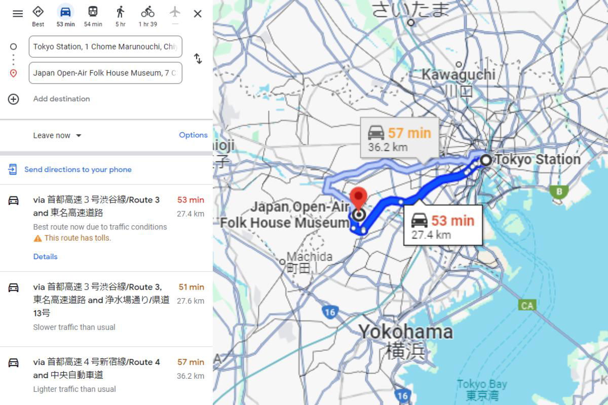
A screenshot of Google Maps showing driving directions from Tokyo Station to the Japan Open-Air Folk House Museum (Nihon Minka-en). The left panel lists the two address fields with an "Add destination" option below, a "Leave now" dropdown, and three route suggestions. The top route takes 53 minutes over 27.4 km via the Shuto Expressway Route 3 and Tomei Expressway, with a note that traffic is heavier than usual and the route has tolls. The two alternatives take 51 minutes over 27.6 km and 57 minutes over 36.2 km. On the map, the recommended route is drawn as a thick blue line running west from Tokyo Station through the city toward the museum, marked with a red pin between Machida and Yokohama. A callout on the map repeats the fastest option at 53 minutes and 27.4 km, while a second callout shows a 57-minute, 36.2 km option. The map covers the greater Tokyo area, including Kawaguchi to the north, Yokohama to the south, and Tokyo Bay at the lower right.
A screenshot of Google Maps showing driving directions from Tokyo Station to the Japan Open-Air Folk House Museum (Nihon Minka-en). The left panel lists the two address fields with an "Add destination" option below, a "Leave now" dropdown, and three route suggestions. The top route takes 53 minutes over 27.4 km via the Shuto Expressway Route 3 and Tomei Expressway, with a note that traffic is heavier than usual and the route has tolls. The two alternatives take 51 minutes over 27.6 km and 57 minutes over 36.2 km.
On the map, the recommended route is drawn as a thick blue line running west from Tokyo Station through the city toward the museum, marked with a red pin between Machida and Yokohama. A callout on the map repeats the fastest option at 53 minutes and 27.4 km, while a second callout shows a 57-minute, 36.2 km option. The map covers the greater Tokyo area, including Kawaguchi to the north, Yokohama to the south, and Tokyo Bay at the lower right.
圖片中的可見文字
Best
53 min
54 min
5 hr
1 hr 39
Tokyo Station, 1 Chome Marunouchi, Chi
Japan Open-Air Folk House Museum, 7 C
Add destination
Leave now
Options
Send directions to your phone
via 首都高速 3 号渋谷線/Route 3 and 東名高速道路
53 min
27.4 km
Best route now due to traffic conditions
⚠ This route has tolls.
Details
via 首都高速 3 号渋谷線/Route 3, 東名高速道路 and 浄水場通り/県道 13号
51 min
27.6 km
Slower traffic than usual
via 首都高速 4 号新宿線/Route 4 and 中央自動車道
57 min
36.2 km
Lighter traffic than usual
さいたま
Kawaguchi
川口
57 min
36.2 km
Tokyo Station
B
Japan Open-Air Folk House Museum
53 min
27.4 km
Machida
町田
16
Yokohama
横浜
CA
Tokyo Bay
東京湾
16
搭乘電車
搭乘電車前來也是非常方便的方式,大約需要一小時時間,依所選路線而定。通常需要轉車一次,從「向丘遊園」站(Odakyu線)步行到博物館只需約13分鐘。此外,也可以改搭公車,公車會在博物館附近下車。
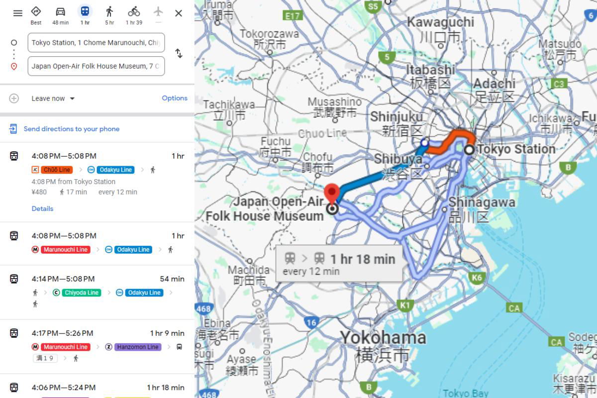
This is a screenshot of a Google Maps directions search showing how to get from Tokyo Station to the Japan Open-Air Folk House Museum (Nihon Minka-en). On the left, a panel lists transit options with departure and arrival times, line badges for connections like the Chūō Line, Marunouchi Line, Chiyoda Line, Hanzōmon Line, and Odakyu Line, travel durations ranging from 54 minutes to over an hour, and a fare of ¥480. A callout on the map highlights a route of 1 hr 18 min running every 12 minutes. The map itself shows central Tokyo and Yokohama, with Tokyo Station marked on the right and the museum marked with a red pin to the southwest, near the Odakyu Line. The chosen route is drawn in orange and blue heading west out of the city.
This is a screenshot of a Google Maps directions search showing how to get from Tokyo Station to the Japan Open-Air Folk House Museum (Nihon Minka-en). On the left, a panel lists transit options with departure and arrival times, line badges for connections like the Chūō Line, Marunouchi Line, Chiyoda Line, Hanzōmon Line, and Odakyu Line, travel durations ranging from 54 minutes to over an hour, and a fare of ¥480. A callout on the map highlights a route of 1 hr 18 min running every 12 minutes.
The map itself shows central Tokyo and Yokohama, with Tokyo Station marked on the right and the museum marked with a red pin to the southwest, near the Odakyu Line. The chosen route is drawn in orange and blue heading west out of the city.
圖片中的可見文字
The user wants me to extract text from a Google Maps screenshot. Let me read through the image carefully.
Left panel (directions UI):
- Icons at top: "Best", "48 min" (car), "1 hr" (transit), "5 hr" (walking), "1 hr 39" (bicycling)
- Input fields: "Tokyo Station, 1 Chome Marunouchi, Chi..." and "Japan Open-Air Folk House Museum, 7 C..."
- "Leave now" with dropdown, "Options"
- "Send directions to your phone"
- Route 1: "4:08 PM—5:08 PM", "1 hr", badges "Chūō Line", "Odakyu Line", walking icon, "4:08 PM from Tokyo Station", "¥480", "17 min", "every 12 min", "Details"
- Route 2: "4:08 PM—5:08 PM", "1 hr", "Marunouchi Line", "Odakyu Line", walking icon
- Route 3: "4:14 PM—5:08 PM", "54 min", walking icon, "Chiyoda Line", "Odakyu Line", walking icons
- Route 4: "4:17 PM—5:26 PM", "1 hr 9 min", "Marunouchi Line", "Hanzomon Line", "薄 1 9" (station number badge, probably "薄 1 9"? It shows "薄 1 9" - actually likely "漕 1 9"? Hmm. It looks like "薄 1 9" but that could be a station badge. Let me think - Hanzomon line... the badge says something like "Z 1 9"? Actually the badge shows "薄" - no wait, Hanzomon Line station badges are "Z" numbers. The image shows "薄 1 9"? Hard to tell. It appears to be "薄 1 9" but I should be careful. Actually looking at it, it says "薄 1 9" — hmm, could be "渋"? The text shows small characters. It looks like "薄 1 9". Actually the Hanzomon line station near... Shibuya is Z01? No, Shibuya is Z01? Hanzomon Line stations: Shibuya Z01, Omote-sando Z02... Hmm. But the route starts from Tokyo Station via Marunouchi Line to Otemachi, then Hanzomon Line... The badge could be "Z 1 5" or similar. The image shows "薄 1 9"? I can't be certain. Since the rule says omit uncertain text, I could omit it or include what I see. It looks like "薄 1 9" - maybe it's "Z 1 5"? The rendering shows "薄 1 9". I'll include "薄 1 9"? Hmm, risky. Actually the badge appears red-ish with characters "薄 1 9"? The color in description: "薄 1 9" badge appears yellowish/white. Tokyo Metro Hanzomon Line badge in Google Maps is purple with "Z" number. The badge shown is small. It might say "Z 1 5" but displayed as... The pixels show "薄 1 9"? I think it's actually "Z 1 5"? Not sure. Given uncertainty, maybe omit the badge. But it's clearly readable as some text... I'll include it as it appears: "薄 1 9"? Hmm.
Actually, thinking about it: the route goes Marunouchi Line from Tokyo Station to Otemachi, then Hanzomon Line from Otemachi (Z06? no). Otemachi is Z08? Hanzomon Line: Shibuya Z01, Omotesando Z02, Aoyama-itchome Z03, Nagatacho Z04, Hanzomon Z05, Kudanshita Z06, Jimbocho Z07, Otemachi Z08, Mitsukoshimae... no wait Otemachi Z08, Suitengumae Z09? Actually: Z08 Otemachi? Hanzomon line stations: Shibuya, Omote-sando, Aoyama-itchome, Nagatacho, Hanzomon, Kudanshita, Jimbocho, Otemachi, Mitsukoshimae, Suitengumae, Kiyosumi-shirakawa, Sumiyoshi, Kinshicho, Oshiage. Otemachi = Z08. The badge might show "Z 0 8"? But image shows something like "薄 1 9"? Hmm, but the display shows two separate numbers "1 9"? Or "Z 1 9"? The extracted text I see: "薄 1 9". Actually wait, maybe it's "渋 1 9"? No.
Hmm, the small badge might be a transfer badge showing line symbols. Given uncertainty, per rules I should omit what I can't read with high confidence. But it does look like "薄 1 9". Hmm, "薄" doesn't make sense. Could be "Z"? Google Maps shows Tokyo Metro badges like "Z 08". The image rendering "薄 1 9" might actually be "Z 0 8"? I'll just omit this small badge since uncertain. Actually, let me reconsider: it says "薄 1 9" per my reading of the image. Hmm... Actually the badge could be showing "表 1 9"? No.
Wait - maybe it's a station badge for Otemachi? Otemachi station badges: Marunouchi "M 19"? No, M19 is... Marunouchi Line stations: M01 Ikebukuro... Tokyo Station is M17, Otemachi M18? Hmm, Otemachi is M18? Actually Marunouchi Line: M17 Tokyo, M18 Otemachi, M19 Awajicho? No: M19 is Shin-Ochanomizu? Let me recall: Marunouchi line: Ikebukuro M25, ... Tokyo M17, Otemachi M18, Awajicho M19? Hmm no. Marunouchi Line: M01 Ikebukuro, M02 Hongo-sanchome, M03 Korakuen, M04 Yotsuya, M05 Yotsuya-sanchome, M06 Shinjuku-gyoemmae, M07 Shinjuku-sanchome, M08 Aoyama-itchome, M09 Omote-sando, M10 Shibuya, M11? No wait, that's reversed. The Marunouchi line runs Ikebukuro to Ogikubo. M25 Ogikubo... The main line: Ikebukuro M25, Hongo-sanchome M24, Otemachi M23? Hmm, actually: Ikebukuro M25, Hongo-sanchome M24, Otemachi M23, Tokyo M17? That doesn't line up. Tokyo Station is M17? Let me think: M17 Tokyo, M18 Otemachi, M19 Awajicho, M20 Ochanomizu... Hmm, actually order from Tokyo: Tokyo (M17), Otemachi (M18)? No—Tokyo then Ginza? The Marunouchi Line: Tokyo M17, Ginza M16... going southwest. Going northeast from Tokyo: Otemachi M18, Awajicho M19, Ochanomizu M20, Hongo-sanchome M21, Korakuen M22, Myogadani M23, Shin-otsuka M24, Ikebukuro M25. Yes! That's right.
So "薄 1 9" might be "M 1 9"? Hmm, the badge might show "M 19"? But wait, the badge is next to Hanzomon Line badge. Transfer at Otemachi? Otemachi M18. Hmm "M 1 9"? Hmm.
Actually the badge in the image appears to say "薄 1 9" — maybe it's "M 1 9"? The rendering could be misread. Given the uncertainty about the first character, I could omit the badge entirely, or write "M 1 9"? Hmm.
Hmm, wait. Actually the destination is Japan Open-Air Folk House Museum in Kawasaki. Route via Marunouchi Line and Hanzomon Line: Tokyo Station → Otemachi (M18/Z08)? Hmm, but the badge... Could be "Z 0 8"? The image seems to show "薄 1 9" though. Hmm, could the badge be "渋"? No.
Given the rule "If a word or character cannot be read with certainty, omit it", I think the safest is to omit that small badge, since I can't confidently determine it. Actually, looking at the pixel description again: "薄 1 9" — it appears as a small white badge with red-ish? Actually it's listed with a light background. The text "薄 1 9"... Hmm.
Hmm, alternatively it could be "薄 1 9" where "薄" is actually "表"? No.
I'll omit it. Actually, let me reconsider - maybe include "M 1 9"? If the first char is a Latin letter in a colored box, Google Maps shows like "M 19". The image shows... it's tiny. I'll omit to be safe. Hmm, but the rule says include only what's readable with high confidence. The "1 9" part... I'm not confident. Omit the whole badge.
- Route 5: "4:06 PM—5:24 PM", "1 hr 18 min" (partially cut at bottom)
Map area text:
- "Iruma" (top left, partially visible - "Trumā"? It shows "Iruma" with "入間市" below? The top shows "iruma" and "入間市" partially cut. Top-left shows "Trumã"? Let me look: "iruma" at very top with "入間市" partially visible. The visible text: "Iruma" and "入間市" cut off at top.
- "E17" shield, "S5" shield
- "Tokorozawa 所沢市"
- "Kawaguchi 川口市"
- "Matsudo 松戸市"
- "5" shield
- "Itabashi 板橋区"
- "Adachi 足立区" (partially cut "足立区"? shows "Adachi 足立区" - the characters "足立区" with "立" partially?)
- "C3" shield
- "Tachikawa 立川市"
- "Musashino 武蔵野市"
- "Shinjuku 新宿区"
- "Chuo Line"
- "Ichikawa 市川市"
- "F..." (cut off at right - "Fu" partially, omit since cut? It shows "Fu" - hmm, probably Funabashi. Since cut off, I could include "Fu" or omit. The rules say never guess cropped characters. I could include just "Fu"? That seems odd. Better omit partially cut words? The rules say omit unreadable. Partially visible "Fu" — I think it's safer to omit. Hmm, but it is readable as "Fu". I'll omit partial words at edges. Actually "Ichikawa 市川市" is fully visible. The "Fu" at edge - I'll omit.
- "Fuchu 府中市"
- "Chofu 調布市"
- "Shibuya 渋谷区"
- "Tokyo Station"
- "B" shield (right side)
- "Japan Open-Air Folk House Museum" (map label with red pin)
- "Shinagawa 品川区"
- "Machida 町田市"
- "1 hr 18 min" "every 12 min" (in the white info box on map)
- "K6" shield, "K1" shield
- "468" shield (two instances, left side bottom and bottom)
- "Odakyu Enoshima..." vertical text along road: "Odakyu Enoshima" partially - vertical text "Odakyu Enoshima" (cut off at bottom). It shows vertical "Odakyu Enoshima" line? I see "Odakyu Enoshima" vertical along the road. Hmm, partially cut. The vertical text reads "Odakyu Enoshima" probably "Odakyu Enoshima Line". Since cut off, I'd include "Odakyu Enoshima" only? Hmm risky. I see "Odakyu Enoshima" letters vertically: O-d-a-k-y-u E-n-o-s-h-i-m-a. I'll include "Odakyu Enoshima"? Actually in the image, the vertical blue road label appears to be "Odakyu Enoshima" - hard to confirm the ending. I'll include it cautiously? Rules: omit if uncertain. The vertical text likely "Odakyu Enoshima Line". Hmm. I might omit. Let me think about what's clearly visible: the letters visible along the vertical road. I'll omit since uncertain.
Actually, let me be a bit more careful and re-examine. The vertical text next to road 16 area: characters going down. I read "Odakyu Enoshima" - it's plausible. But per rules, include only high confidence. I'd say moderately confident. Hmm. I'll include "Odakyu Enoshima" since it appears legible... Actually no. I'll skip it. Hmm.
Let me weigh: The image shows vertical text along a road, likely "Odakyu Enoshima Line" (小田急江ノ島線). The romanized label would be "Odakyu Enoshima Line". If the visible portion is cut at the bottom, including partial text might violate "never invent cropped". I can include only what's visible: "Odakyu Enoshima". If I can read those letters clearly, that's fine. I'll include "Odakyu Enoshima" — hmm, but am I sure about "Enoshima"? The visible letters... I think it says "Odakyu Enoshima". OK, I'll include it. Actually, to be safe, maybe better to omit. The instruction emphasizes high confidence. Road labels in Google Maps are gray text; this one is legible. I'll include "Odakyu Enoshima" — hmm.
Hmm, I realize I should decide. I'll include it as "Odakyu Enoshima" — wait, but if it's cut, the "Line" part is missing. Including "Odakyu Enoshima" is just the visible portion, which is allowed as long as I don't invent. OK.
- "Ebina 海老名市"
- "sugi" (partially, cut at left edge - "sugi" visible? It shows "sugi" near bottom left - probably part of "Sug..." something like "Zsugi"? It's cut. Omit? It shows "sugi" - likely part of "Isehara"? no. Probably "Ebisu"? Hmm. It's cut off at left. Omit partial. Actually it might be part of "Zama"? No. "sugi" — could be "Ōi"? Hmm, omit.
- "Ayase 綾瀬市"
- "16" shield
- "Yokohama 横浜市"
- "CA" shield (two instances on right)
- "B" shield (bottom)
- "Sode..." cut at right ("Sodegaura"? shows "Sode" + "袖ヶ..." - partially visible: "Sodegaura 袖ヶ浦"? It shows "Sode" and "袖ケ" partially. Omit partials? It shows "Sodegaura 袖ヶ浦" cut at edge. Hmm. Visible: "Sode" ... "袖ケ". Since cut, omit or include partial? I'll omit cut-off words. Hmm, but "Sode" is readable... it's cropped though. Rules: "Never invent, complete, or guess missing, cropped..." - including only the visible portion is fine, but it might look odd. I'll include what's clearly visible? I think for cropped words, best to omit to avoid noise. Hmm, but the instruction says extract readable text; cropped but readable portions are readable. The spirit: don't guess the rest. I could include "Sode" but that seems like noise. I'll omit edge-cropped fragments. Similarly "iruma"/"入間市" at top is cropped - the top shows "iruma" partially cut (shows "iruma" with descenders cut?). Actually "Iruma" appears mostly visible with "入間市" cut in half. Hmm.
Let me decide on a consistent approach: include text that is readable, even if at edges, as long as the visible characters can be read confidently. For fragments like "Fu", "sugi", "Sode" — these are readable fragments. Hmm. But including fragments could be seen as noise. The instruction: "Extract only the text that is clearly readable". Fragments that are clearly readable count. But "Do not merge text from visually separate areas" and "never guess". I'll include fragments where confident: "Iruma" (top), "入間市" — the Japanese is half-cut; "入間市" characters partially visible. Risky. Hmm.
Let me just go with a reasonable extraction:
Top area: "Iruma 入間市" — the top is cut. I might write "Iruma" only? Or omit. I think including "Iruma 入間市" with partial cut... The screenshot shows "iruma" at very top (cut) and "入間市" below it (cut). I'll include "Iruma" and "入間市" since they're identifiable. Hmm, actually the topmost row: "Trumã"? It looks like "Iruma" with the top cut. And "入間市" below. I'm fairly confident it's "Iruma 入間市". Include.
Left column top icons: "Best 48 min 1 hr 5 hr 1 hr 39" and the X close button.
Input fields:
"Tokyo Station, 1 Chome Marunouchi, Chi..." — visible: "Tokyo Station, 1 Chome Marunouchi, Chi" (cut). I'll include "Tokyo Station, 1 Chome Marunouchi, Chi" — the ellipsis? The field shows text cut with "Chi" partially. I'll write "Tokyo Station, 1 Chome Marunouchi, Chi" — hmm, maybe "Chiyoda". Visible is "Chi". I'll include up to "Chi". Or omit the trailing partial? I'll include "Tokyo Station, 1 Chome Marunouchi, Chi" as that's what's visible. Hmm, it might show "Chi" cut in half. Safer: "Tokyo Station, 1 Chome Marunouchi," — hmm. The image shows "Tokyo Station, 1 Chome Marunouchi, Chi" where "Chi" is partially cut. I'll include "Chi" since readable? It's ambiguous. I'll write "Tokyo Station, 1 Chome Marunouchi, Chi" — acceptable.
Second: "Japan Open-Air Folk House Museum, 7 C" — shows "7 C" partially ("7 Chome"?). Visible "7 C". I'll include "Japan Open-Air Folk House Museum, 7 C". Hmm, maybe "7-..." I see "7 C". OK.
Buttons: "Leave now" with dropdown arrow, "Options", "Send directions to your phone".
Route 1:
"4:08 PM—5:08 PM" (em dash)
"1 hr"
Badges: train icon + "Chūō Line" (orange badge), ">" icon, "Odakyu Line" (blue badge with Odakyu logo), ">" walking icon
"4:08 PM from Tokyo Station"
"¥480 17 min every 12 min"
"Details"
Route 2:
"4:08 PM—5:08 PM"
"1 hr"
"Marunouchi Line" (red badge with M logo), ">", "Odakyu Line", ">", walking icon
Route 3:
"4:14 PM—5:08 PM"
"54 min"
walking icon, ">", "Chiyoda Line" (green with C logo), ">", "Odakyu Line", ">", walking icons (two walking icons? The layout: walking icon > Chiyoda Line > Odakyu Line, then a second row with walking icon). Actually route 3: 🚶 > Chiyoda Line > Odakyu Line, and below another 🚶. So: walking icon, "Chiyoda Line", "Odakyu Line", walking icon.
Route 4:
"4:17 PM—5:26 PM"
"1 hr 9 min"
"Marunouchi Line", ">", "Hanzomon Line" (purple badge with Z logo), ">", train icon
Small badge "薄 1 9"? Hmm — between badges there's a small white badge with "薄 1 9"? Actually looking at position: it's below/left, showing "薄 1 9"? It's probably "M 19"? Hmm wait — Marunouchi Line from Tokyo: transfer at Otemachi? But badge next to Hanzomon... Actually the small badge appears at the start of the line row, before walking icon. Hmm, it shows "薄 1 9"? Hmm, could it be "表"? No.
Actually! Maybe it's "渋 1 9"? Hmm no. Wait — maybe it's a station badge for "Z 1 5"? Let me think about what station: Tokyo Station Marunouchi Line... transfer to Hanzomon at Otemachi (M18/Z08? hmm no, Otemachi on Hanzomon is... let me recheck: Hanzomon Line stations: Shibuya Z01, Omote-sando Z02, Aoyama-itchome Z03, Nagatacho Z04, Hanzomon Z05, Kudanshita Z06, Jimbocho Z07, Otemachi Z08? Hmm, actually I recall Otemachi is Z08? Wait, Mitsukoshimae Z09, Suitengumae Z10, Kiyosumi-shirakawa Z11, Sumiyoshi Z12, Kinshicho Z13, Oshiage Z14. Hmm, but I've also seen Otemachi Z08. Yes Otemachi = Z08.
But wait, route 4 destination is the museum in Kawasaki; Hanzomon Line to Shibuya? then Odakyu from Shibuya. Hmm, but badge "Hanzomon Line" then train icon at end suggests train to... Then the small badge "薄 1 9"? Could be showing transfer station badges: "M 18"? Hmm.
The visible glyphs "薄 1 9" — hmm, maybe it's actually "表 1 9"? No... Maybe it's "M 1 9"? M19 = Awajicho? That doesn't fit either.
You know, in Google Maps, small badges between line badges can show like "M 18" etc. The rendering "薄 1 9" might be my misreading of tiny text. Given uncertainty, omit. Actually, hmm, wait. Could it be "渋 1 9"? No. Could it be "Z 1 9"? Hmm no. Could it be "薄"? There's no station with 薄. Actually there IS: 薄野? No that's Sapporo. Hmm. There's "薄" in... no.
OK omit that tiny badge.
Route 5 (partially visible at bottom):
"4:06 PM—5:24 PM"
"1 hr 18 min"
Below that there's a partial yellow/colored badge cut off — omit.
Map:
- "Iruma 入間市" (top, partially cut)
- "E17", "S5"
- "Tokorozawa 所沢市"
- "Kawaguchi 川口市"
- "Matsudo 松戸市"
- "5"
- "Itabashi 板橋区"
- "Adachi 足立区" — the Japanese shows "足立区"? In the image: "Adachi 足立区" with characters partially cut by the orange route? It shows "足立区"? The image shows "Adachi 足立区" where 立 is partially overlapped. Hmm, it shows "足竝区"? No, it's 足立区 with the route line crossing. I'll include "Adachi 足立区". Actually the visible: "Adachi 足立区" — the middle character partially obscured by orange route. I'll include it as it's identifiable.
Wait, looking again at the description: "Adachi 足竍区"? The pixel shows "足立区" with orange line through. I'll include "Adachi 足立区".
- "C3"
- "Tachikawa 立川市"
- "Musashino 武蔵野市"
- "Shinjuku 新宿区"
- "Chuo Line"
- "Ichikawa 市川市"
- "Fuchu 府中市"
- "Chofu 調布市"
- "Shibuya 渋谷区"
- "Tokyo Station"
- "B"
- "Japan Open-Air Folk House Museum"
- "Shinagawa 品川区"
- "Machida 町田市"
- "1 hr 18 min" / "every 12 min"
- "K6", "K1"
- "468" (twice)
- "Odakyu Enoshima" (vertical) — decide: include? I'll include "Odakyu Enoshima" hmm. Actually the vertical text: "Odakyu Enoshima" — wait, could it read "Odakyu Enoshima Line"? The bottom is cut at "ma" + maybe "Li..."? I see characters down to bottom edge. I'll include "Odakyu Enoshima" only if confident about those letters. Hmm. Honestly I'm not 100% sure. The vertical road label along the blue line near "16"... In reality, that area: Odakyu Enoshima Line runs from Fujisawa... but this map area near Ebina/Ayase... Actually the Odakyu main line runs through Ebina? The Odakyu Enoshima Line: Sagami-Ōno → Fujisawa. The map shows Machida, Ebina, Ayase, Yokohama — the vertical road between Machida and Yokohama area could be Odakyu Odawara Line? Hmm. The romanized label might be "Odakyu Odawara Line"? Hmm.
The visible letters in image (vertical): O,d,a,k,y,u,E,n,o,s,h,i,m,a... I think I see "Odakyu Enoshima". Hmm, but the road goes south from Machida toward Yokohama — that's more like the Odawara Line. But the label could still be Enoshima if positioned near Sagami-Ōno... Sagami-Ōno is near Ebina. The vertical text position is left-center, near "0" of 468? It's between Machida and the 16 road. Hmm.
Given uncertainty, I'll omit the vertical road label. Hmm, or include? The rules say high confidence. I'd say ~60%. Omit.
- "Ebina 海老名市"
- "sugi" — omit (fragment, cut)
- "Ayase 綾瀬市"
- "16"
- "Yokohama 横浜市"
- "CA" (x2)
- "B"
- "Sode" + "袖ケ" — cut at right edge. Omit? "Sodegaura 袖ケ浦" would be Sodegaura. Visible: "Sode" and "袖ケ". Cut. I'll omit. Hmm, or include "Sodegaura 袖ケ浦"? The right edge shows "Sodegaura 袖ケ浦"? The text shows "Sode" + cut. I'll omit cropped ones.
- "Kisarazu 木更津" — bottom right, partially cut: "Kisarazu" and "木更津" with 井? It shows "Kisarazu 木更津" partially (bottom cut). Hmm. Visible "Kisarazu" mostly, "木更津市"? Shows "木更津" + partially "市". I'll include "Kisarazu 木更津"? The bottom row: "Kisarazu" visible, "木更津" visible partially. Hmm. Include "Kisarazu 木更津" — moderately confident. Actually the bottom edge cuts it. I'll include "Kisarazu" and "木更津" since letters are discernible. Hmm, "木更津市" - the 市 might be cut. I'll write "Kisarazu 木更津". Hmm, risky about the 市. I'll do "Kisarazu 木更津".
Hmm wait, also "Tokyo Bay" at bottom right - visible "Tokyo Bay" (light text on water). Include.
Also "6" top right corner shield? Top right shows "6" partially? There's a shield at top right edge showing "6"? I see at very top right "6" in a shield? The image shows top-right corner a green shield with "6"? Hmm, there's "6" at top right. Yes, route 6 sign (国道6号?) Actually top right corner shows a blue/green shield "6". I'll include "6"? It's partially visible. Hmm. The top right shows "6" shield cut. I'll include "6"? Risky. Omit.
Also "B" shield right middle. Include.
Also the ">>" chevrons between badges — I can represent with ">".
Also walking icons — represent as 🚶? The instruction says include only characters readable; icons aren't text. But they convey "walking". Better to omit icons or note? Rules: "Ignore purely visual elements unless they contain text." Icons don't contain text, so omit. But the chevrons ">" are visual too. Hmm. I'll keep it simple: list text lines.
Also the route badges contain small logos (JR, M, C, Z) — the badge text itself is the line names.
Also "Chūō Line" has macron: "Chūō Line". Badge orange with JR logo.
Also the transit icons in "1 hr 18 min" box: train > train icons. Omit.
Also top left panel icons: hamburger, then "Best" under a diamond?, "48 min" under car, "1 hr" under train, "5 hr" under person, "1 hr 39" under bike, then X.
Also "Leave now ▾" and "Options".
Also there's "Send directions to your phone" with a device icon.
Route 1 details: "4:08 PM from Tokyo Station", "¥480 17 min every 12 min", "Details".
Now format: The left panel is a list of route options. I'll present as text with line breaks. No table needed.
Map labels: I'll list them in reading order (top to bottom, left to right). But rule: "Reconstruct the natural reading order based on the visual layout" and "Do not merge text from visually separate areas unless they clearly belong together." Map labels are separate areas. I'll list each on its own line, maybe grouped.
Let me draft:
---
Best
48 min
1 hr
5 hr
1 hr 39
Tokyo Station, 1 Chome Marunouchi, Chi
Japan Open-Air Folk House Museum, 7 C
Leave now
Options
Send directions to your phone
4:08 PM—5:08 PM
1 hr
Chūō Line
Odakyu Line
4:08 PM from Tokyo Station
¥480
17 min
every 12 min
Details
4:08 PM—5:08 PM
1 hr
Marunouchi Line
Odakyu Line
4:14 PM—5:08 PM
54 min
Chiyoda Line
Odakyu Line
4:17 PM—5:26 PM
1 hr 9 min
Marunouchi Line
Hanzomon Line
4:06 PM—5:24 PM
1 hr 18 min
Map:
Iruma
入間市
E17
S5
Tokorozawa
所沢市
Kawaguchi
川口市
Matsudo
松戸市
5
Itabashi
板橋区
Adachi
足立区
C3
Tachikawa
立川市
Musashino
武蔵野市
Shinjuku
新宿区
Chuo Line
Fuchu
府中市
Chofu
調布市
Ichikawa
市川市
Shibuya
渋谷区
Tokyo Station
B
Japan Open-Air Folk House Museum
Shinagawa
品川区
Machida
町田市
1 hr 18 min
every 12 min
K6
K1
468
Ebina
海老名市
Ayase
綾瀬市
16
Yokohama
横浜市
CA
CA
B
Tokyo Bay
Kisarazu
木更津
---
Hmm, should I include "Map:" heading? That's my own addition — no, don't add anything. Just output extracted text.
Also the em dash in times: "4:08 PM—5:08 PM" — Google uses "–" (en dash) typically. It shows "4:08 PM—5:08 PM". I'll use "–"? The image shows a dash; hard to tell en vs em. Google Maps uses en dash "–". I'll use "–". Hmm, or "-"? I'll use "–" as it appears as a longer dash. Actually Google Maps route list uses "–" I believe. I'll go with "–".
Also "Chūō Line" — with macrons. Yes.
Order within route 3: walking icon then Chiyoda Line then Odakyu Line; also second walking icon below. I'll just include the line names.
Also should I include "Details" link. Yes.
Also the top has "Best" label under a diamond icon; "48 min", "1 hr", "5 hr", "1 hr 39" under respective icons. Include as separate lines.
Should I include "468" twice? It appears twice on map (left side). I'll include once? It's two separate labels. Hmm, both are "468". Listing twice is more faithful; once is fine too. I'll list once to avoid duplication confusion. Actually rules don't prohibit duplicates. I'll include it twice? Meh, once.
Also "CA" appears twice (right side). Include both? I'll include once each unique... Hmm. I'll just include them as they appear in reading order. Keep duplicates minimal: I'll include "CA" once? Reading order top-to-bottom: CA (upper right), then CA (lower right). I'll include both? It's noise. I'll include each unique label once but keep major ones. Actually fidelity: I'll include duplicates since they're at different locations. Hmm, I'll keep it simple and include once for CA, once for 468, once for B, once for 5. Hmm but there are two "B" shields (right middle and bottom center). Ugh.
I think listing each unique text once is cleaner and still faithful. But strictly, "preserve" suggests as shown. I'll list in reading order with duplicates where clearly distinct positions. Let me include: "B" appears twice — I'll include both? I'll just include once. Fine.
Decision: unique labels listed top-to-bottom, left-to-right-ish.
Also "Iruma 入間市" is cut at top — include "Iruma" and "入間市"? The Japanese is half-cut but recognizable. I'll include both. Hmm, the very top shows "iruma" partially and "入間市" partially cut horizontally. I'll include "Iruma 入間市". Actually, to be safe with "never guess cropped characters", the characters that ARE visible are readable. "入間市" — the top halves visible? I think it's fine.
Also "Matsudo 松戸市" top right — visible fully. Include.
Also "Ichikawa 市川市" — include. And "Fu" cut — omit.
Also "足立区" — orange line crosses it but readable. Include.
Also "品川区" partially overlapped by blue route? Readable. Include.
Also bottom "Kisarazu 木更津" — cut at bottom. Include "Kisarazu" and "木更津"? The characters visible: "Kisarazu" full? It shows "Kisarazu" and "木更津" with 市 possibly cut. I'll include "Kisarazu 木更津". Hmm, actually the image bottom right shows "Kisarazu" and below "木更津" (and possibly "井"? no). I'll include "Kisarazu 木更津". Hmm, risk on the Japanese. It looks like "木更津". OK include.
Also "Sode" cut — omit. And "袖ケ" cut — omit.
Also "sugi" — omit.
Also "Odakyu Enoshima" vertical — hmm, decide final: I'll omit. Actually... let me reconsider once more. In the image there's clearly vertical gray text along the road left of "16". The letters I can discern... The visible letters look like "Odakyu Enoshima" reading downward. Real-world: that vertical road near Ebina/Ayase going south is the Odakyu Enoshima Line? No — the Enoshima line is west. The vertical road there... Actually Hon-Atsugi area, the road going south along the Sakai river toward Yamato... Hmm, the Odakyu Odawara Line runs north-south through Hon-Atsugi → Ebina → Yamato → Sagami-Ōno... The label might be "Odakyu Odawara Line". Hmm, but I read "Enoshima". If the road is the Tōmei Expressway? No, that's "CA"-marked? Hmm.
Given my uncertainty about the exact wording, omit. Final: omit vertical text.
Also "Chuo Line" on map (gray label) — include.
Also numbers on shields: E17, S5, 5, C3, K6, K1, 16, 468, CA, B, 6(cut, omit), B.
Also "Route 5" partial bottom: there's a partial colored bar under it (cut) — omit.
Also should the "X" close button be included? It's a symbol, not text. Omit.
Also "¥480" — include with yen sign.
Also "Options" and "Leave now". Include.
Also "Send directions to your phone". Include.
Also the second input's "7 C" — include as "7 C"? It shows "7 C" cut. Hmm "7-..." I'll write "7 C". Hmm, is it "7 C" or "7 C..."? The visible: "Japan Open-Air Folk House Museum, 7 C" — I'll include that.
First input: "Tokyo Station, 1 Chome Marunouchi, Chi" — hmm the "Chi" is cut mid-character? It shows "Chi" then cut. I'll include "Chi". Or omit "Chi"? I'll include "Chi" — it's readable letters. Eh... Actually if it's cut mid-letter, including partial letters is fine as long as I don't guess. "Chi" seems readable. Keep.
Format the output: plain text with line breaks. Should I group map labels with line breaks? Yes.
One more: "1 hr 39" (bike) — top shows "1 hr 39" where "39" is below "1 hr"? It shows "1 hr 39" stacked. I'll write "1 hr 39".
Also "48 min" under car, "Best" under diamond (best route icon), "1 hr" under transit, "5 hr" under walking.
Final output structure:
Best
48 min
1 hr
5 hr
1 hr 39
Tokyo Station, 1 Chome Marunouchi, Chi
Japan Open-Air Folk House Museum, 7 C
Leave now
Options
Send directions to your phone
4:08 PM–5:08 PM 1 hr
Chūō Line
Odakyu Line
4:08 PM from Tokyo Station
¥480
17 min
every 12 min
Details
4:08 PM–5:08 PM 1 hr
Marunouchi Line
Odakyu Line
4:14 PM–5:08 PM 54 min
Chiyoda Line
Odakyu Line
4:17 PM–5:26 PM 1 hr 9 min
Marunouchi Line
Hanzomon Line
4:06 PM–5:24 PM 1 hr 18 min
Iruma
入間市
E17
S5
Tokorozawa
所沢市
Kawaguchi
川口市
Matsudo
松戸市
5
Itabashi
板橋区
Adachi
足立区
C3
Tachikawa
立川市
Musashino
武蔵野市
Shinjuku
新宿区
Chuo Line
Fuchu
府中市
Chofu
調布市
Shibuya
渋谷区
Tokyo Station
B
Japan Open-Air Folk House Museum
Shinagawa
品川区
Machida
町田市
1 hr 18 min
every 12 min
K6
K1
468
Ebina
海老名市
Ayase
綾瀬市
16
Yokohama
横浜市
CA
B
Tokyo Bay
Kisarazu
木更津
Wait — reading order: "Ichikawa 市川市" is on the right side at ~y=235, above "Tokyo Station". Let me order map labels by vertical position:
- Iruma 入間市 (top, cut)
- E17 (~y=30)
- S5 (top)
- Tokorozawa 所沢市 (~y=75)
- Kawaguchi 川口市 (~y=45)
- Matsudo 松戸市 (~y=95)
- 5 (~y=115)
- Itabashi 板橋区 (~y=145)
- Adachi 足立区 (~y=170)
- C3 (~y=165)
- Tachikawa 立川市 (~y=220)
- Musashino 武蔵野市 (~y=210)
- Shinjuku 新宿区 (~y=235)
- Chuo Line (~y=270)
- Fuchu 府中市 (~y=290)
- Chofu 調布市 (~y=320)
- Shibuya 渋谷区 (~y=330)
- Tokyo Station (~y=300)
- B (~y=340)
- Japan Open-Air Folk House Museum (~y=415)
- Shinagawa 品川区 (~y=415)
- Machida 町田市 (~y=545)
- 1 hr 18 min / every 12 min (~y=520)
- K6 (~y=555)
- K1 (~y=615)
- 468 (~y=590) and 468 (~y=790)
- Ebina 海老名市 (~y=650)
- Ayase 綾瀬市 (~y=725)
- 16 (~y=650)
- Yokohama 横浜市 (~y=700)
- CA (~y=620 right), CA (~y=690 right)
- B (~y=775)
- Tokyo Bay (~y=790)
- Kisarazu 木更津 (~y=760)
Order in output roughly top-to-bottom. Fine.
Should "Ichikawa 市川市" be included — yes around y=235 right side.
Let me also double check "Chūō Line" badge: it says "Chūō Line" — yes with macron over u and o.
"Marunouchi Line" red badge. "Odakyu Line" blue. "Chiyoda Line" green. "Hanzomon Line" purple.
Times: "4:08 PM—5:08 PM" — I'll use en dash "–".
Also should I keep "1 hr" next to time on same line? I'll put on same line separated by space or keep separate lines. I'll do same line: "4:08 PM–5:08 PM 1 hr"? To be clean, maybe:
4:08 PM–5:08 PM
1 hr
Hmm, they're on the same visual row (time left, duration right). I'll combine with a few spaces. I'll write:
4:08 PM–5:08 PM 1 hr
That reads oddly but reflects layout. Alternatively keep separate. I'll put them on one line separated by spaces (right-aligned in original). Fine.
Also note the em dash might be "–". OK.
Also "Send directions to your phone" is a link with icon.
Also include "Details" for route 1 only (visible).
Also route 5 shows a partial yellow/orange badge at very bottom cut — omit.
I think the answer is ready. Should I add a "Map labels" separator? No, just text. But then map labels merge with panel text confusingly. The rules say return only extracted text; separators like blank lines are OK. I'll separate with blank lines.
One concern: "Best" — it's a label under the diamond icon. Include. Yes.
Also the top-left hamburger icon — no text.
Also "X" — it's a close icon (letter X shape). It's a symbol; probably omit. Hmm, "X" is a letter but it's an icon. I'll omit.
Final answer.Best
48 min
1 hr
5 hr
1 hr 39
Tokyo Station, 1 Chome Marunouchi, Chi
Japan Open-Air Folk House Museum, 7 C
Leave now
Options
Send directions to your phone
4:08 PM–5:08 PM 1 hr
Chūō Line
Odakyu Line
4:08 PM from Tokyo Station
¥480
17 min
every 12 min
Details
4:08 PM–5:08 PM 1 hr
Marunouchi Line
Odakyu Line
4:14 PM–5:08 PM 54 min
Chiyoda Line
Odakyu Line
4:17 PM–5:26 PM 1 hr 9 min
Marunouchi Line
Hanzomon Line
4:06 PM–5:24 PM 1 hr 18 min
Iruma
入間市
E17
S5
Tokorozawa
所沢市
Kawaguchi
川口市
Matsudo
松戸市
5
Itabashi
板橋区
Adachi
足立区
C3
Tachikawa
立川市
Musashino
武蔵野市
Shinjuku
新宿区
Chuo Line
Ichikawa
市川市
Fuchu
府中市
Chofu
調布市
Shibuya
渋谷区
Tokyo Station
B
Japan Open-Air Folk House Museum
Shinagawa
品川区
Machida
町田市
1 hr 18 min
every 12 min
K6
K1
468
Ebina
海老名市
Ayase
綾瀬市
16
Yokohama
横浜市
CA
CA
B
Tokyo Bay
Kisarazu
木更津
戶外博物館的不同區域
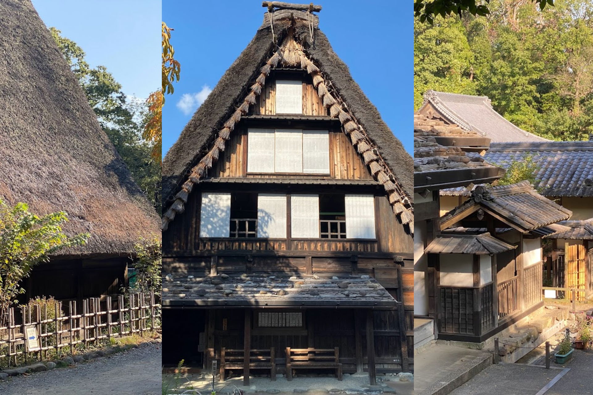
「日本民家園」戶外博物館分為五大區域,每個區域皆展示不同類型的日本傳統民家。這些區域分別為「驛站城鎮」、「信越村」、「關東村」、「神奈川村」以及「東北村」。館內總共展出20多座民宅,呈現出不同地區與時代的建築特色。
傳統樸實建築的工法
漫步於民家園,你會看到各種不同用途的日本民宅建築:包括農家、水車屋以及漁民之家等。
民家內展示了過去日常生活所需的物品及農業器具。不同民家讓人深入了解當時日本的生活方式與建築發展歷史,尤其是建築結構非常獨特,令人印象深刻。
日本傳統建築的一大特色就是因應地震的安全需求。大型建築多採用較有彈性的木骨架為主要結構,夾層牆用較輕的材料,這樣的樸實民居被稱為「Minka(民家)」。Minka 是日本文化的重要一環,體現傳統的生活方式,這種工法經歷百年演變,是日本建築藝術珍貴的遺產。
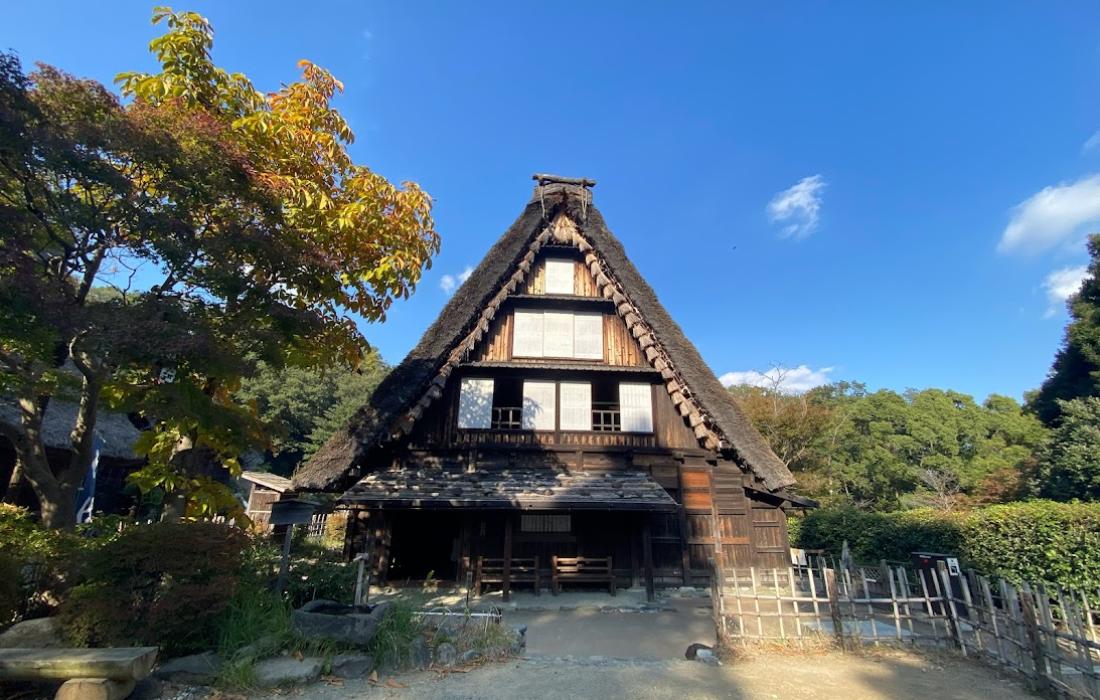
A steep, thatched-roof farmhouse stands at the center of the photo under a clear blue sky, its enormous gable rising to a sharp peak in the classic gassho-zukuri style, where the roofline resembles two hands pressed together in prayer. The thick thatch covers a dark wooden frame, and the upper floors open with rows of small windows and white paper panels, some slid aside to show the timber lattice behind them. At ground level a sheltered entrance porch runs along the front, with simple wooden benches set against the entrance below. The house sits in a relaxed museum setting, framed on the left by a tall tree turned orange and gold with autumn color, and on the right by a low wooden fence and shrubs. A dirt path leads toward the entrance, and the whole scene has the calm, preserved feel of Nihon Minka-en, the open-air museum of relocated traditional Japanese farmhouses.
A steep, thatched-roof farmhouse stands at the center of the photo under a clear blue sky, its enormous gable rising to a sharp peak in the classic gassho-zukuri style, where the roofline resembles two hands pressed together in prayer. The thick thatch covers a dark wooden frame, and the upper floors open with rows of small windows and white paper panels, some slid aside to show the timber lattice behind them. At ground level a sheltered entrance porch runs along the front, with simple wooden benches set against the entrance below.
The house sits in a relaxed museum setting, framed on the left by a tall tree turned orange and gold with autumn color, and on the right by a low wooden fence and shrubs. A dirt path leads toward the entrance, and the whole scene has the calm, preserved feel of Nihon Minka-en, the open-air museum of relocated traditional Japanese farmhouses.
圖片中的可見文字
No clearly readable text.
免費英文導覽
戶外博物館提供免費的導覽服務,由志工導覽員以英文講解日本民家的一切豐富資訊。若5人以上預約,即可成團,並需於參觀日前兩週以電子郵件報名。
如果人數不足而無法成團,也可使用博物館提供的免費語音導覽。此外,遇到天候狀況、預約爆滿或同時有其他活動時,導覽可能暫停。
雖然我自己沒參加這個導覽,但我覺得這是深入認識日本民家建築史的極好機會。
你可以在這裡免費預約導覽: https://www.nihonminkaen.jp/guided_tours.html
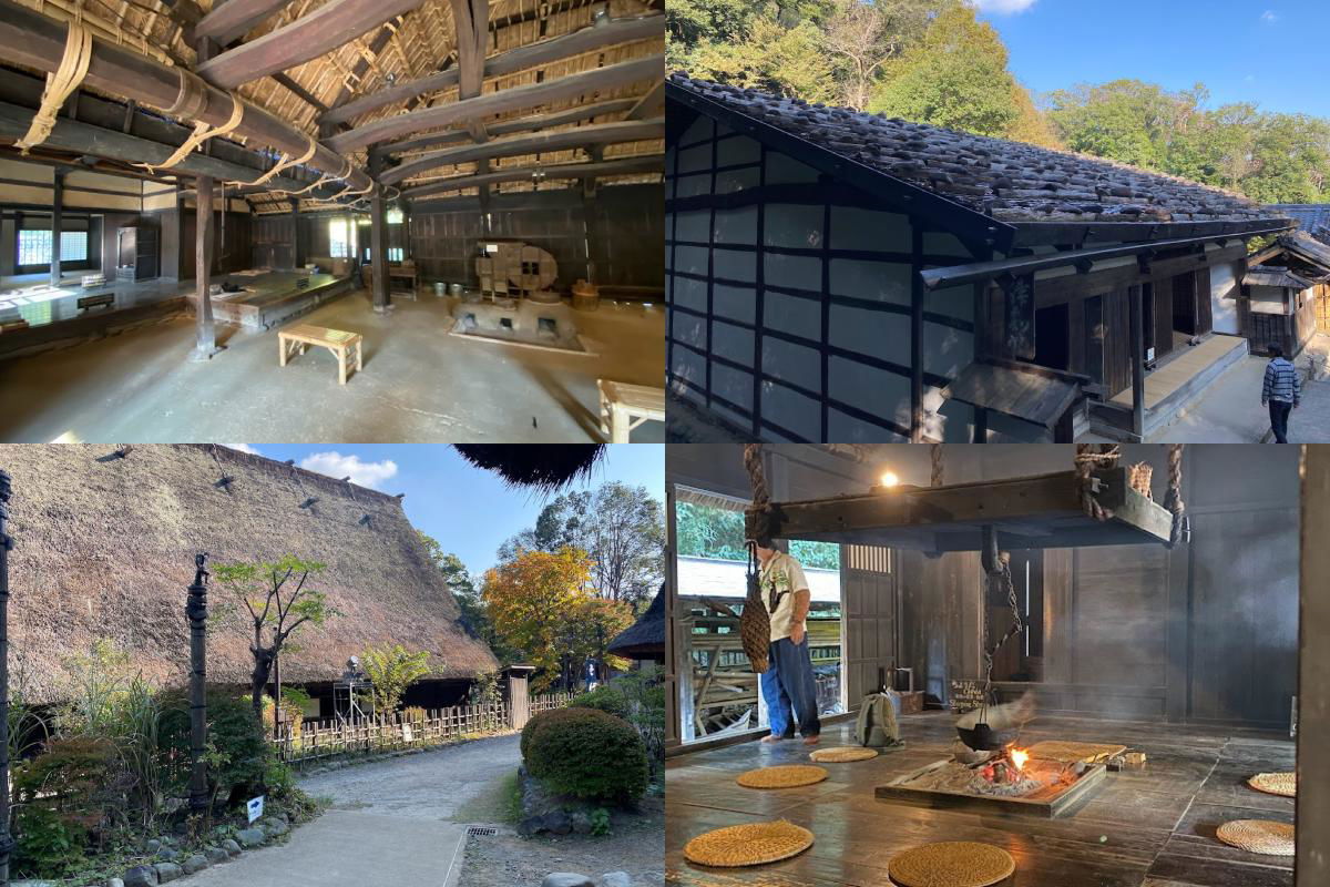
A four-photo collage from Nihon Minka-en, the open-air museum of traditional Japanese folk houses in Kawasaki. Top left shows the dim interior of a farmhouse, with massive curved wooden beams under a thatched roof, a packed-earth floor, a sunken hearth, and old household tools and a wooden bench along the walls. Top right shows a house exterior with dark stone-tiled roofing and white plaster-and-timber walls, set against a forested hillside under a blue sky, with one visitor walking past. Bottom left is an exterior view of a large thatched roof house along a gravel path, surrounded by hedges, bamboo fence, and autumn trees. Bottom right shows inside the house, where a visitor stands near the entrance beside a large adjustable wooden hearth hook suspended by ropes over a sunken fire pit; the open hearth burns with small flames, smoke drifting up, and round woven straw cushions are laid on the wooden floor around it.
A four-photo collage from Nihon Minka-en, the open-air museum of traditional Japanese folk houses in Kawasaki.
Top left shows the dim interior of a farmhouse, with massive curved wooden beams under a thatched roof, a packed-earth floor, a sunken hearth, and old household tools and a wooden bench along the walls. Top right shows a house exterior with dark stone-tiled roofing and white plaster-and-timber walls, set against a forested hillside under a blue sky, with one visitor walking past. Bottom left is an exterior view of a large thatched roof house along a gravel path, surrounded by hedges, bamboo fence, and autumn trees. Bottom right shows inside the house, where a visitor stands near the entrance beside a large adjustable wooden hearth hook suspended by ropes over a sunken fire pit; the open hearth burns with small flames, smoke drifting up, and round woven straw cushions are laid on the wooden floor around it.
圖片中的可見文字
No clearly readable text is present in the image.
展覽與手作工坊
戶外博物館定期舉辦主題展覽與各類手作體驗課程。多數展覽免費參觀。如果你想參加體驗項目,例如學習藍染工藝,則需額外付費並須事先預約。
更多展覽與工坊的資訊在這裡: https://www.nihonminkaen.jp/temporary_exhibition.html
開放時間與票價
「日本民家園」戶外博物館每年3月至10月開放時間為9:30至17:00(最後入場16:30);11月至隔年2月則為9:30至16:30(最後入場16:00)。每週一休館,若逢國定假日則照常開放。日本連假過後隔日亦開放。每年12月29日至隔年1月3日因年終年初而暫停營業。
成人票價為 550 日圓,大學生及65歲以上為 330 日圓。兒童及持有身障手冊者免費入場。
開放時間:
3月至10月:9:30 至 17:00
11月至2月:09:30 至 16:30
週一休館
票價:
成人:550 日圓
大學生及65歲以上:330 日圓
兒童:免費
持有身心障礙證明者:免費
川崎市民:免費
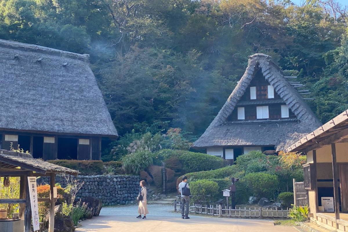
Two traditional Japanese farmhouses with thick thatched roofs dominate the scene at the Nihon Minka-en open-air museum. The one on the right has the dramatic steep triangular gable of gassho-zukuri architecture, its dark wooden frame rising over three rows of white-shuttered windows. The house on the left sits lower on a stone-walled terrace, its wide thatched roof sloping nearly to the ground. Wisps of smoke drift up from among the dense green trees between them, hinting at a hearth burning inside. On the path below, a woman in a long beige dress and a man with a backpack pause to look around, surrounded by trimmed shrubs and a low wooden fence. The forested hillside behind closes in the whole valley-like grounds, with the first hints of autumn color showing at the edges.
Two traditional Japanese farmhouses with thick thatched roofs dominate the scene at the Nihon Minka-en open-air museum. The one on the right has the dramatic steep triangular gable of gassho-zukuri architecture, its dark wooden frame rising over three rows of white-shuttered windows. The house on the left sits lower on a stone-walled terrace, its wide thatched roof sloping nearly to the ground. Wisps of smoke drift up from among the dense green trees between them, hinting at a hearth burning inside. On the path below, a woman in a long beige dress and a man with a backpack pause to look around, surrounded by trimmed shrubs and a low wooden fence. The forested hillside behind closes in the whole valley-like grounds, with the first hints of autumn color showing at the edges.
圖片中的可見文字
国指定
ガイド
重要備註與資訊
博物館對遊客及家庭提供多項便利設施。館內數量有限的輪椅與嬰兒車可供租借。在9號野原家屋附近設有附有尿布台的廁所。室內設有無障礙廁所。如你計畫攜帶腳架或畫架入場作畫,請事先通知總辦公室。禁止進行商業攝影,也禁止攜帶寵物入館。吸菸、飲食僅可於指定區域進行。
結語
戶外博物館距離東京不遠且交通便利。這裡是遠離都市喧囂、深入認識日本民家文化的好地方。票價合理,尤其還有免費英文導覽,真的很棒!


評論