
สารบัญ:
TL;DR
ถ้าจะไปญี่ปุ่นแล้วอยากเห็นทะเลดอกไม้สวยๆ ต้องแวะฮิตาชิซีไซด์พาร์คที่จังหวัดอิบารากิ จุดขายคือดอกเนโมฟิลาสีน้ำเงินช่วงฤดูใบไม้ผลิ กับพุ่มโคเคียสีแดงระเบิดช่วงกลางถึงปลายเดือนตุลาคม ค่าเข้าไม่แพง ผู้ใหญ่ 450 เยนนอกฤดูกาล แต่ช่วงดอกบานราคาขึ้นเป็น 800 เยน และระวังคนเยอะมากโดยเฉพาะวันหยุดสุดสัปดาห์ เหมาะเป็นทริปเดย์ทริปหนีจากโตเกียวสุดๆเคยได้ยินเกี่ยวกับ Hitachi Seaside Park ในจังหวัดอิบารากิ ประเทศญี่ปุ่นหรือไม่? ถ้ายังไม่เคย คุณควรเพิ่มสถานที่นี้ลงในลิสต์ที่ต้องไปให้ได้ใน การเดินทางครั้งต่อไปของคุณที่ญี่ปุ่น สวนที่น่าประทับใจแห่งนี้มีชื่อเสียงด้านการจัดแสดงดอกไม้อันน่าทึ่ง และมีกิจกรรมและสถานที่ท่องเที่ยวมากมายสำหรับผู้มาเยือนทุกวัย
ค่าเข้าชม
ราคาถือว่าสมเหตุสมผลสำหรับสวนที่คุณสามารถใช้เวลาได้ทั้งวัน โปรดทราบว่าในช่วงฤดูกาลดอกไม้บานหลัก (เช่น Nemophila และ Kochia) จะมีราคาตามฤดูกาลที่สูงกว่า [1]
นอกช่วงฤดูกาลพีค
| ราคา [2] | |
|---|---|
| ผู้ใหญ่ (มัธยมปลายขึ้นไป) | ¥450 |
| ผู้สูงอายุ (65 ปีขึ้นไป) | ¥210 |
ในช่วงฤดูกาล (Peak Season)
| ราคา [3] | |
|---|---|
| ผู้ใหญ่ (มัธยมปลายขึ้นไป) | ¥800 |
| ผู้สูงอายุ (65 ปีขึ้นไป) | ¥560 |
ทะเลดอกไม้สีน้ำเงิน
สวนแห่งนี้มีชื่อเสียงด้านดอกทิวลิปที่สวยงามน่าทึ่งใน ฤดูใบไม้ผลิ แต่แม้ในฤดูร้อนและฤดูใบไม้ร่วง คุณก็ยังสามารถเพลิดเพลินกับดอกไม้และต้นไม้เขียวขจีได้หลากหลายชนิด โดยเฉพาะอย่างยิ่งดอก Nemophila สีน้ำเงินนับไม่ถ้วน (Baby Blue Eyes) ที่เปลี่ยนพื้นที่กว้างใหญ่ของสวนให้กลายเป็นทะเลดอกไม้ที่ไม่เหมือนใคร เป็นฉากหลังที่น่าตื่นตาตื่นใจสำหรับผู้มาเยือนทุกคน
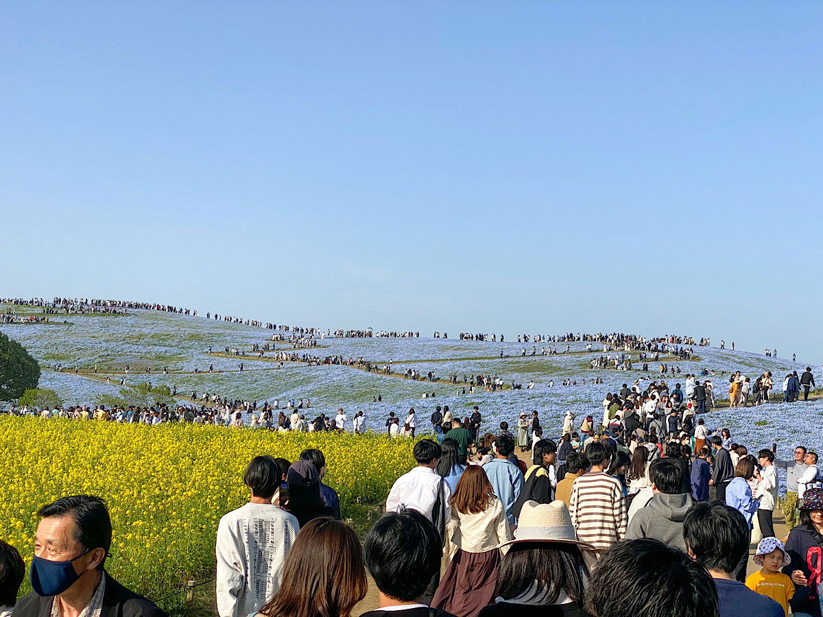
Rolling hills blanketed in blue nemophila flowers stretch under a pale, clear sky at Hitachi Seaside Park in Ibaraki Prefecture. The slopes look almost painted, a soft blue sea of blossoms broken only by the dirt paths winding through them. Crowds of visitors cover the hilltop and the trails in the middle ground, scattered thin at the crest and packed densely along a wide walkway lower down. In the foreground, a bright band of yellow rapeseed flowers frames the blue, and dozens of people stroll toward the camera in light spring clothing, some in masks or sun hats, one woman in a wide straw hat standing out among the dark heads. The scene captures peak bloom season, when the park draws visitors by the thousands.
Rolling hills blanketed in blue nemophila flowers stretch under a pale, clear sky at Hitachi Seaside Park in Ibaraki Prefecture. The slopes look almost painted, a soft blue sea of blossoms broken only by the dirt paths winding through them. Crowds of visitors cover the hilltop and the trails in the middle ground, scattered thin at the crest and packed densely along a wide walkway lower down. In the foreground, a bright band of yellow rapeseed flowers frames the blue, and dozens of people stroll toward the camera in light spring clothing, some in masks or sun hats, one woman in a wide straw hat standing out among the dark heads. The scene captures peak bloom season, when the park draws visitors by the thousands.
ข้อความที่ปรากฏในภาพ
No clearly readable text.
Summer Cypress ในฤดูใบไม้ร่วง
ฉันมีโอกาสได้ไปเยือน Hitachi Seaside Park อีกครั้ง—คราวนี้ใน ฤดูใบไม้ร่วง จริงๆ แล้วสวนแห่งนี้มีการจัดแสดงพืชและดอกไม้ที่เบ่งบานในช่วงเวลาต่างๆ ของปีอย่างไม่เหมือนใคร
ในฤดูใบไม้ร่วง สถานที่ท่องเที่ยวหลักคือพุ่ม Kochia หรือที่เรียกว่า summer cypress ซึ่งจะเปลี่ยนเป็นสีแดงสดใส ฤดูกาลนี้อยู่ช่วงกลางถึงปลายเดือนตุลาคม ในช่วงเวลาเหล่านี้สวนอาจค่อนข้างแน่นขนัด โดยเฉพาะในวันหยุดสุดสัปดาห์
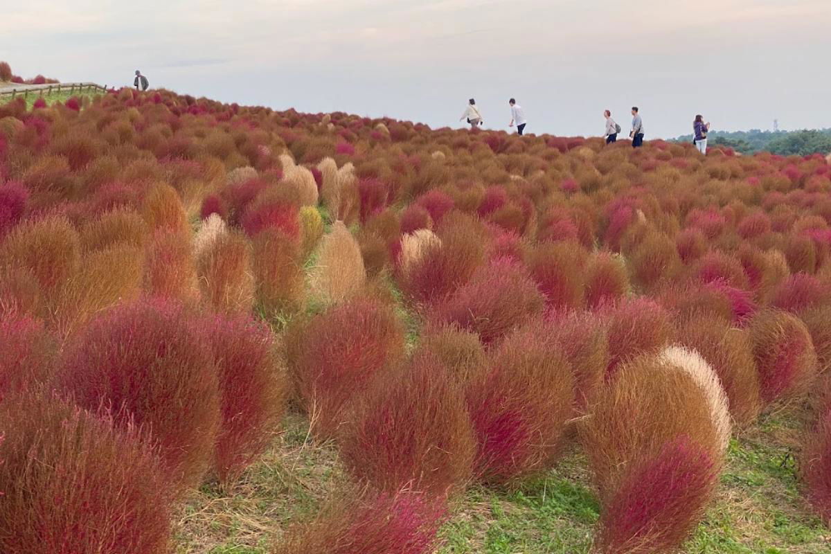
A hillside at Hitachi Seaside Park in Ibaraki Prefecture, Japan, blanketed in autumn kochia, the rounded bushy plants that turn fiery red each fall. The slope is packed with them, a mix of deep crimson, rust orange, and pale tan where some bushes have not fully turned, swelling up toward the crest of the hill. A handful of visitors in light jackets walk along the ridgeline, small against the field, taking in the view. The sky above is a flat, overcast white, and a dark line of trees runs along the far horizon.
A hillside at Hitachi Seaside Park in Ibaraki Prefecture, Japan, blanketed in autumn kochia, the rounded bushy plants that turn fiery red each fall. The slope is packed with them, a mix of deep crimson, rust orange, and pale tan where some bushes have not fully turned, swelling up toward the crest of the hill. A handful of visitors in light jackets walk along the ridgeline, small against the field, taking in the view. The sky above is a flat, overcast white, and a dark line of trees runs along the far horizon.
ข้อความที่ปรากฏในภาพ
No text is clearly readable in the image.
สัมผัสประสบการณ์ทริปหนึ่งวันสุดสีสันนอกกรุงโตเกียว: ชื่นชมพุ่ม Kochia ที่สดใสใน Hitachi Seaside Park เพลิดเพลินกับการเก็บผลไม้ตามฤดูกาล (เช่น องุ่น ลูกแพร์ หรือเกาลัด) และรับประทานบุฟเฟต์อิตาเลียน
การผสมผสานอันผ่อนคลายระหว่างธรรมชาติ ความสุขสบาย และบรรยากาศชนบท—เหมาะสำหรับการพักผ่อนสั้นๆ ในฤดูใบไม้ร่วง!
*ลิงก์พันธมิตร: หากคุณจองกิจกรรมบน viator.com ผ่านวิดเจ็ตหรือลิงก์ของฉัน ฉันจะได้รับค่าคอมมิชชันเล็กน้อย โดยไม่มีค่าใช้จ่ายเพิ่มเติมสำหรับคุณ และคุณจะช่วยสนับสนุนบล็อกของฉัน ฉันรู้สึกขอบคุณมากและขอให้คุณสนุกกับการเดินทาง (^_^)
กิจกรรมและสถานที่ท่องเที่ยวภายในสวน
นอกจากการจัดแสดงดอกไม้แล้ว ยังมีกิจกรรมและสถานที่ท่องเที่ยวมากมายให้ค้นพบภายในสวน ลองปั่นจักรยานเลียบทะเลดอกไม้ หรือขึ้นชิงช้าสวรรค์ (Ferris wheel) เพื่อชมวิวอันน่าตื่นตาตื่นใจของสวนและภูมิทัศน์โดยรอบดูไหม?
หากคุณชอบใจเย็นๆ คุณสามารถนั่งพักผ่อนบนม้านั่งมากมายในสวนและเพลิดเพลินกับธรรมชาติ จัดปิกนิกสุดฟินพร้อมผ้าปูปิกนิก (อาจเป็น Bento ทำเองที่บ้าน?) หรือพักผ่อนที่ร้านอาหารริมทาง (เปิดเฉพาะช่วงฤดูกาล) หรือคาเฟ่ต่างๆ
เคล็ดลับ: วางแผนการเยี่ยมชม & เตรียมตัว
เพื่อให้การเยี่ยมชม Hitachi Seaside Park ของคุณเป็นประสบการณ์ที่ไม่มีวันลืม คุณควร วางแผนทริป ล่วงหน้าและเตรียมตัวให้ดี สวนอาจคนแน่นมาก โดยเฉพาะในช่วงฤดูดอกไม้บาน ดังนั้นควรมาแต่เช้าหรือมาเยี่ยมชมในวันธรรมดาจะดีที่สุด
ครั้งหนึ่งฉันไปที่นั่นใน ฤดูหนาว สวนแทบว่างเปล่า แต่ก็มีดอกไม้น้อยมาก ในช่วงพีคซีซัน คือ ฤดูใบไม้ผลิ จะมีผู้มาเยือนหลายร้อยหรือแม้กระทั่งหลายพันคน แต่จนถึงตอนนี้ฉันยังไม่เคยเห็นคิวยาวที่ทางเข้าเลย
อย่าลืมพกกล้องติดตัวไปเพื่อบันทึกภาพการจัดแสดงดอกไม้อันน่าทึ่ง และอย่าลืมครีมกันแดดและหมวก เพราะแสงแดดในญี่ปุ่นช่วง ฤดูใบไม้ผลิและฤดูร้อน แรงมาก
โดยรวมแล้ว Hitachi Seaside Park เป็นไฮไลต์สุดๆ และเป็นสถานที่ที่ นักเดินทางสู่ญี่ปุ่น ทุกคนต้องมา การผสมผสานระหว่างดอกไม้อันน่าทึ่งและกิจกรรมกับสถานที่ท่องเที่ยวมากมายทำให้สวนแห่งนี้น่าจดจำอย่างแท้จริง งั้นไป Ibaraki-ken กันเลย!
การเดินทางไปที่นั่นโดยรถไฟ
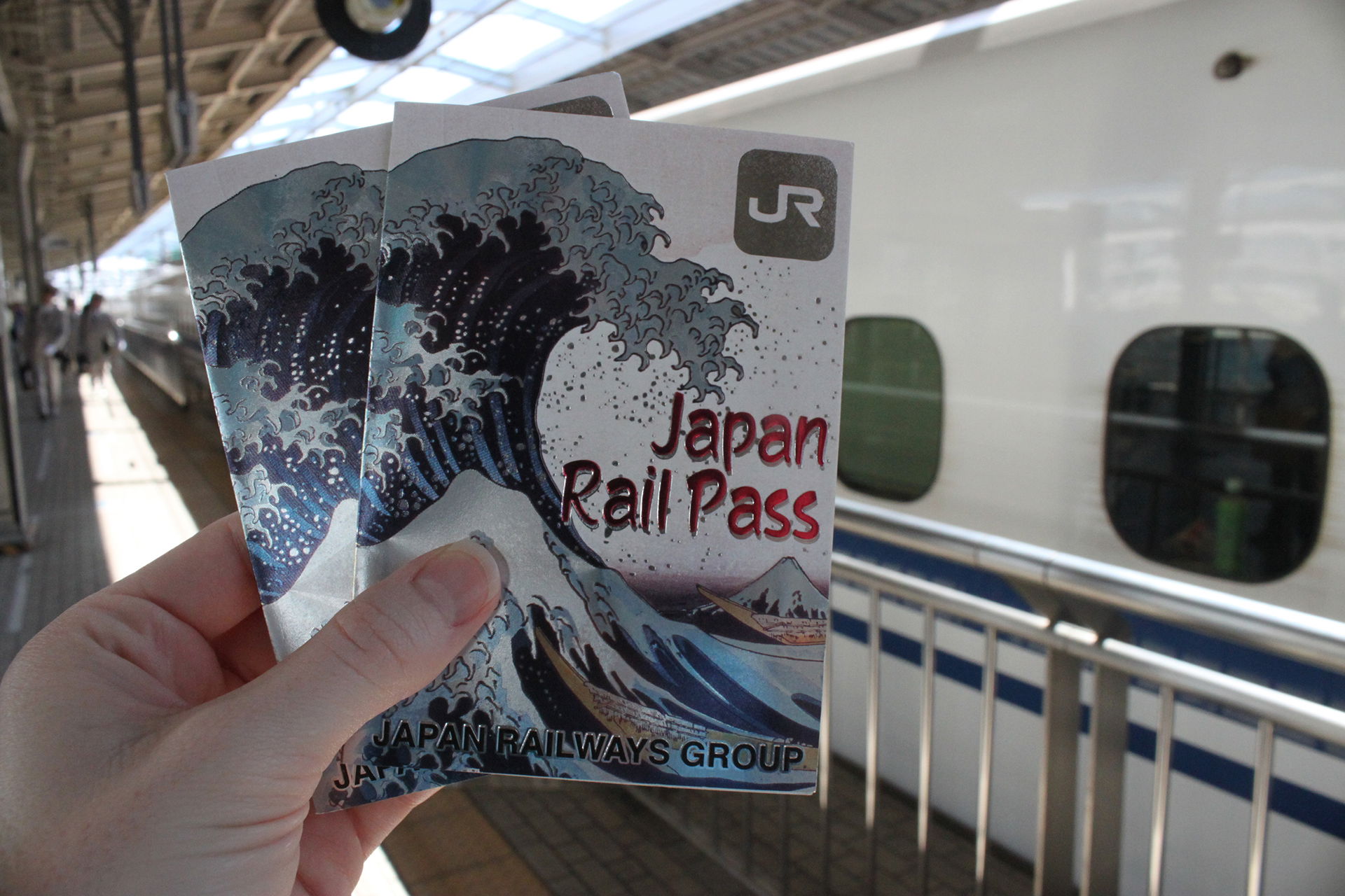
เวลาเดินทางจาก โตเกียว ใช้เวลาราว 2 ถึง 2.5 ชั่วโมง ขึ้นอยู่กับจุดเริ่มต้นของคุณ ด้วย Japan Rail Pass คุณสามารถนั่งสาย JR Joban ไปยังสถานี Katsuta จากนั้นจะมีรถบัสไปที่สวน (ประมาณ 15-20 นาที) ฉันแนะนำให้จัดเวลาทั้งวันสำหรับทริปนี้ เพื่อให้คุณมีเวลาเพลิดเพลินกับสวนที่สวยงามและทำความคุ้นเคยกับ การเดินทางด้วยรถไฟในญี่ปุ่น
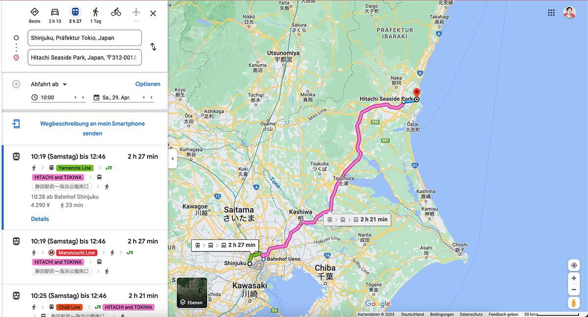
A Google Maps route planner in German shows directions from Shinjuku in Tokyo to Hitachi Seaside Park in Ibaraki Prefecture. The left panel lists the starting point and destination, a departure time of 10:00 on Saturday, April 29, and three transit options, each taking roughly two and a half hours. The routes combine a Tokyo Metro line, such as the Yamanote or Marunouchi Line, with a highway bus marked "HITACHI and TOKIWA," with fares around 4,290 yen. The map on the right traces the journey with a bright pink line from Shinjuku through Ueno, Saitama, and Chiba Prefecture up to a red pin on the coast at Hitachi Seaside Park, near the city of Hitachi. Surrounding cities like Utsunomiya, Tsukuba, and Chiba are labeled in German transliteration alongside Japanese characters.
A Google Maps route planner in German shows directions from Shinjuku in Tokyo to Hitachi Seaside Park in Ibaraki Prefecture. The left panel lists the starting point and destination, a departure time of 10:00 on Saturday, April 29, and three transit options, each taking roughly two and a half hours. The routes combine a Tokyo Metro line, such as the Yamanote or Marunouchi Line, with a highway bus marked "HITACHI and TOKIWA," with fares around 4,290 yen.
The map on the right traces the journey with a bright pink line from Shinjuku through Ueno, Saitama, and Chiba Prefecture up to a red pin on the coast at Hitachi Seaside Park, near the city of Hitachi. Surrounding cities like Utsunomiya, Tsukuba, and Chiba are labeled in German transliteration alongside Japanese characters.
ข้อความที่ปรากฏในภาพ
Beste 2 h 10 2 h 27 1 Tag
Shinjuku, Präfektur Tokio, Japan
Hitachi Seaside Park, Japan, 〒312-0012
Abfahrt ab
Optionen
10:00
Sa, 29. Apr.
Wegbeschreibung an mein Smartphone senden
10:19 (Samstag) bis 12:46 2 h 27 min
Yamanote Line
HITACHI and TOKIWA
勝田駅前→海浜公園入口
10:28 ab Bahnhof Shinjuku
4.290 ¥ 23 min
Details
10:19 (Samstag) bis 12:46 2 h 27 min
Marunouchi Line
HITACHI and TOKIWA
勝田駅前→海浜公園入口
10:25 (Samstag) bis 12:46 2 h 21 min
Chūō Line HITACHI and TOKIWA
Präfektur IBARAKI
Utsunomiya 宇都宮
Nikko 日光
Sakura さくら
Kanuma 鹿沼
Yaita 矢板
Ota 太田
Ashikaga 足利
Tochigi 栃木
Kumagaya 熊谷
Kuki 久喜
Kawagoe 川越
Saitama さいたま
Oyama 小山
Mooka 真岡
Tsukuba つくば
Tsuchiura 土浦
Kashiwa 柏
Katori 香取
Kashima 鹿嶋
Kamisu 神栖
Naka 那珂
Oarai 大洗
Hitachi Seaside Park
2 h 27 min
2 h 21 min
Bahnhof Ueno
Shinjuku
Hokuso Line
Narita 成田
Chiba 千葉
Asahi 旭
Chōshi 銚子
Kawasaki 川崎
Togane 東金
Yokaichiba 八日市場
Sakura Line
JR
Google
Kartendaten © 2023 Deutschland Bedingungen Datenschutz Feedback geben 20 km
Ebenen
การเดินทางไปที่นั่นโดยรถยนต์
การขับรถจากโตเกียวใช้เวลาราว 2 ถึง 3 ชั่วโมง ขึ้นอยู่กับสภาพจราจร หากคุณกำลังพิจารณา การขับรถในญี่ปุ่น หรือใช้ รถเช่า คุณสามารถจอดรถได้ที่สวนโดยตรง ค่าจอดรถคือ ¥520 สำหรับรถยนต์ทั่วไป, ¥260 สำหรับรถจักรยานยนต์ และ ¥1,580 สำหรับยานพาหนะขนาดใหญ่ [4]
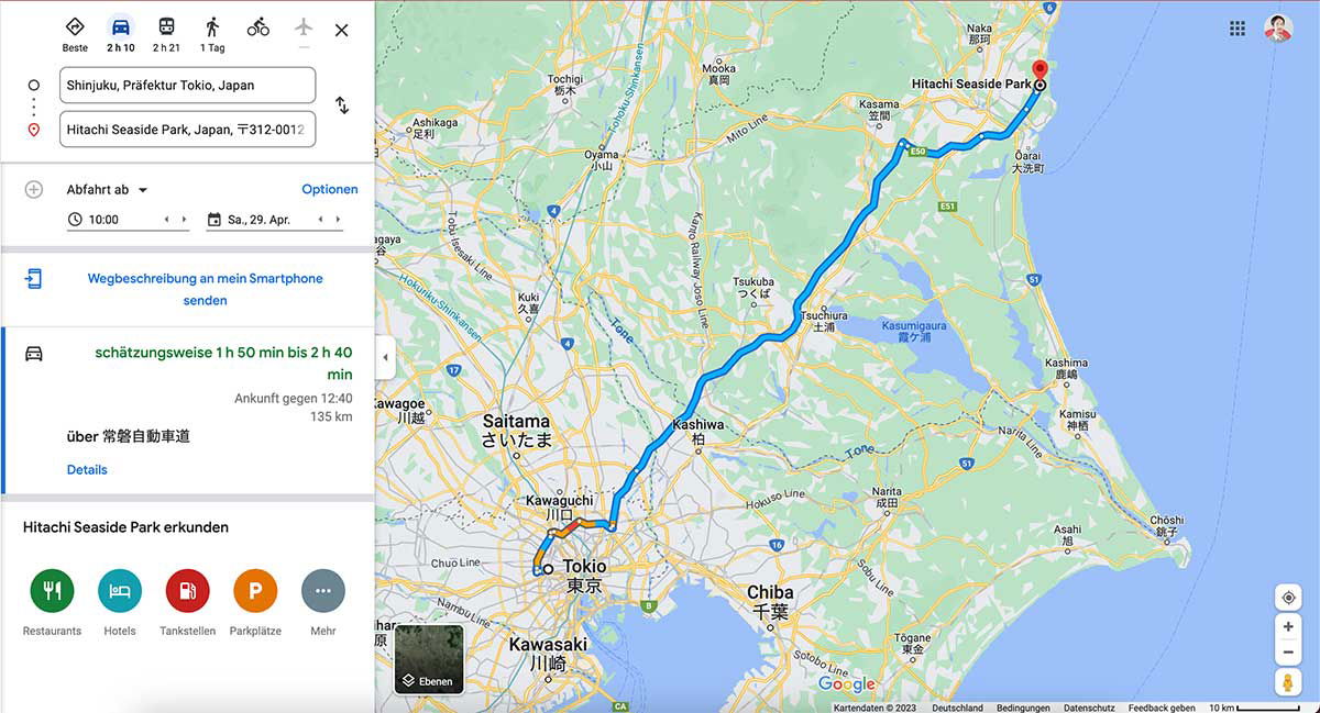
A Google Maps screenshot with a German interface shows the driving route from Tokyo to Hitachi Seaside Park in Ibaraki Prefecture. The left panel lists the start point in Shinjuku and the park as the destination, with a departure set for 10:00 on Saturday, April 29. The estimated drive is 1 hour 50 minutes to 2 hours 40 minutes over 135 km, arriving around 12:40, with the route running via the Jōban Expressway. Options below include sending the directions to a smartphone, and a row of icons for restaurants, hotels, gas stations, and parking. On the map, a bold blue line traces the route northeast out of Tokyo, past Saitama and Kashiwa, through the Tsukuba area, and up the coast to the park, which is marked with a red pin at the top right. Surrounding labels place the scene in the wider region: Chiba and Kawasaki to the south, Kashima and Lake Kasumigaura near the coast, and the Pacific Ocean running along the right edge of the frame.
A Google Maps screenshot with a German interface shows the driving route from Tokyo to Hitachi Seaside Park in Ibaraki Prefecture. The left panel lists the start point in Shinjuku and the park as the destination, with a departure set for 10:00 on Saturday, April 29. The estimated drive is 1 hour 50 minutes to 2 hours 40 minutes over 135 km, arriving around 12:40, with the route running via the Jōban Expressway. Options below include sending the directions to a smartphone, and a row of icons for restaurants, hotels, gas stations, and parking.
On the map, a bold blue line traces the route northeast out of Tokyo, past Saitama and Kashiwa, through the Tsukuba area, and up the coast to the park, which is marked with a red pin at the top right. Surrounding labels place the scene in the wider region: Chiba and Kawasaki to the south, Kashima and Lake Kasumigaura near the coast, and the Pacific Ocean running along the right edge of the frame.
ข้อความที่ปรากฏในภาพ
The user wants me to extract text from a Google Maps screenshot. Let me carefully read all the text visible in the image.
Top left panel:
- Icons with labels: "Beste", "2 h 10", "2 h 21", "1 Tag"
- Input fields: "Shinjuku, Präfektur Tokio, Japan" and "Hitachi Seaside Park, Japan, 〒312-0012"
- "Abfahrt ab ▼" with "Optionen"
- "10:00" and "Sa., 29. Apr."
- "Wegbeschreibung an mein Smartphone senden"
- "schätzungsweise 1 h 50 min bis 2 h 40 min"
- "Ankunft gegen 12:40"
- "135 km"
- "über 常磐自動車道"
- "Details"
- "Hitachi Seaside Park erkunden"
- Icons: "Restaurants", "Hotels", "Tankstellen", "Parkplätze", "Mehr"
- "Ebenen" (map layer button)
Map labels:
- Naka 那珂
- Hitachi Seaside Park
- Mooka 真岡
- Kasama 笠間
- Tochigi 栃木
- Oyama 小山
- Ōarai 大洗町
- Ashikaga 足利
- Mito Line
- E51, E50, E6, R4, 51, 354, R16, 296, B, C4, R125, 408, 17, 122, 6, 16, 357, 51, 408, 245...
- Tsukuba つくば
- Kasumigaura 霞ヶ浦
- Kuki 久喜
- Kano Railway Joso Line
- Tone
- Kashima 鹿嶋
- Kamisu 神栖
- Saitama さいたま
- Kashiwa 柏
- Nariita Line (actually "Narita Line")
- Kawagoe 川越
- Kawaguchi 川口
- Narita 成田
- Hokuso Line
- Choshi 銚子
- Asahi 旭
- Tokio 東京
- Chiba 千葉
- Tōgane 東金
- Kawasaki 川崎
- Chuo Line
- Nambu Line (partially visible "har" — cropped)
- Sotobo Line
- Tōhoku Shinkansen (partially visible)
- Tsukuba Express?
- Tobu ... Line labels
- Joban...
- "Tone" river labels
- Google
- Kartendaten ©2023 Deutschland Bedingungen Datenschutz Feedback geben 10 km
Let me reconstruct carefully. I should only include text I can read with high confidence.
Left panel:
- "Beste"
- "2 h 10"
- "2 h 21"
- "1 Tag"
- "Shinjuku, Präfektur Tokio, Japan"
- "Hitachi Seaside Park, Japan, 〒312-0012"
- "Abfahrt ab"
- "Optionen"
- "10:00"
- "Sa., 29. Apr."
- "Wegbeschreibung an mein Smartphone senden"
- "schätzungsweise 1 h 50 min bis 2 h 40 min"
- "Ankunft gegen 12:40"
- "135 km"
- "über 常磐自動車道"
- "Details"
- "Hitachi Seaside Park erkunden"
- "Restaurants"
- "Hotels"
- "Tankstellen"
- "Parkplätze"
- "Mehr"
- "Ebenen"
Map place labels (clearly readable):
- "Naka" / "那珂"
- "Hitachi Seaside Park"
- "Mooka" "真岡"
- "Kasama" "笠間"
- "Tochigi" "栃木"
- "Oyama" "小山"
- "Ōarai" "大洗町"
- "Ashikaga" "足利"
- "Tsukuba" "つくば"
- "Kasumigaura" "霞ヶ浦"
- "Kuki" "久喜"
- "Kashima" "鹿嶋"
- "Kamisu" "神栖"
- "Saitama" "さいたま"
- "Kashiwa" "柏"
- "Kawagoe" "川越"
- "Kawaguchi" "川口"
- "Narita" "成田"
- "Tokio" "東京"
- "Chiba" "千葉"
- "Tōgane" "東金"
- "Kawasaki" "川崎"
- "Choshi" "銚子"
- "Asahi" "旭"
Route numbers: E50, E51, E6, R4, 17, 122, 16, 51, 354, R16, 296, 125, 408, B, C4, 6, 51, 16, 296...
Some of these are small; I'll include ones I can be confident about: E50, E51, E6, R4, R16, 354, 51, 408, 17, 122, 16, 296, B, C4, 245? Hard to say. I'll include a modest set.
Rail lines: "Mito Line", "Tobu Skytree Line"? The vertical text near left says "Tōhoku Shinkansen" and "Tobu Isesaki"? Let me think. Vertical text at left: "Hokusō..." Actually visible: "Tsukuba Express"? The text near top-left vertical: "Tōbu ... Line". I see "Mito Line", "Kano Railway Joso Line", "Hokuso Line", "Narita Line" (appears as "Nariita Line"? likely "Narita Line"), "Chuo Line", "Sotobo Line", "Nambu Line" (cropped, shows "...har"?). There's "Kasumigaura" etc.
Vertical texts: "Tōhoku Shinkansen" (rotated), "Tsukuba Express"? The one near Tsukuba says "Kano Railway Joso Line". Another says "Tobu Nikko Line"? Hard.
I'll include only clearly readable ones: "Mito Line", "Kano Railway Joso Line", "Hokuso Line", "Narita Line", "Chuo Line", "Sotobo Line", "Tone" (river, appears twice), "Kasumigaura", "Tōhoku Shinkansen"? The rotated text near top-left edge reads "Tobu Skytree Line"? I see "Tsukuba Express"? Not confident. There is "Hokuso Line" clearly. Also "Mito Line" near top. Also "Nariita Line" — it's "Narita Line".
Bottom: "Kartendaten ©2023 Deutschland Bedingungen Datenschutz Feedback geben 10 km" and "Google".
Also "Ebenen" button.
Cropped text at left edge: "har" and "ngaya"? "Kawagoe" area: "Kawa..." "川越" with "gaya"? There's "Nishikokubunji"? Not visible. I'll skip cropped ones.
Also "Tsuchiura 土浦" — I see "Tsuchiura" and "土浦" near the lake. Yes there's "Tsuchiura 土浦" label near Kasumigaura.
Also "Ushiku"? Not clearly. "Ryugasaki"? Not clearly.
Also "Toride"? Not visible.
Also "Yuki"? Not visible.
Also "Chiyoda"? Not visible.
Map also shows "Kamisu 神栖", "Kashima 鹿嶋".
Also "Naka 那珂" at top.
Also "Ōarai 大洗町".
Also "Sakai"? no.
Route numbers visible: E50 (top right area), E6, E51, R4, 17, 122, 16, 51, 354, 408, 125, 296, R16, B, C4, 6, 16, 296, 51, 245? I'll include: E6, E50, E51, R4, R16, C4, B, 6, 16, 17, 51, 122, 296, 354, 408. Some may be misread; but these are typical. Confidence: E50 yes, E51 yes, E6 yes, R4 yes, 354 yes, 51 yes, 408 yes, R16 yes, 17 yes, 122 yes, 16 yes, 296 yes, B yes, C4 yes, 6 yes.
Also "10 km" scale, "Kartendaten ©2023", "Deutschland", "Bedingungen", "Datenschutz", "Feedback geben", "Google".
The title attribute? Not needed.
Also small text "Tsuchiura" "土浦" — yes.
Also "Ushiku"? I see "牛久"? Not clearly.
Also "Toride"? no.
Also "Joso"? no.
Also "Bando"? no.
Also "Inashiki"? no.
Also "Hokota"? no.
Also "Itako"? no.
Also "Namegata"? no.
Also "Omitama"? no.
Also "Ishioka"? Not clearly; there's something near the lake west: "Ishioka"? I can't confirm.
Also "Tone" appears twice (river Tone). I'll include once or twice.
Also "Kasumigaura 霞ヶ浦".
Also "Hitachinaka"? The top shows "Naka 那珂" only. There is "Hitachinaka"? Not visible clearly; the red pin is at Hitachi Seaside Park.
Also "Tokai"? Not clearly.
OK. Also left sidebar top icons row: "Beste", "2 h 10", "2 h 21", "1 Tag". These are transport mode labels with times.
Also the "⇅" swap icon — no text.
Output format: reconstructed reading order. I'll produce left panel first, then map labels, then footer.
I should present as text, maybe with headings structure. Keep it simple, list-like. Since it's a screenshot, not a table, I'll just produce lines.
Let me write:
Beste
2 h 10
2 h 21
1 Tag
Shinjuku, Präfektur Tokio, Japan
Hitachi Seaside Park, Japan, 〒312-0012
Abfahrt ab
Optionen
10:00
Sa., 29. Apr.
Wegbeschreibung an mein Smartphone senden
schätzungsweise 1 h 50 min bis 2 h 40 min
Ankunft gegen 12:40
135 km
über 常磐自動車道
Details
Hitachi Seaside Park erkunden
Restaurants
Hotels
Tankstellen
Parkplätze
Mehr
Ebenen
Map labels:
Naka 那珂
Hitachi Seaside Park
Mooka 真岡
Kasama 笠間
Tochigi 栃木
Oyama 小山
Ōarai 大洗町
Ashikaga 足利
Mito Line
Tsukuba つくば
Tsuchiura 土浦
Kasumigaura 霞ヶ浦
Kuki 久喜
Kano Railway Joso Line
Tone
Saitama さいたま
Kashiwa 柏
Kawagoe 川越
Kawaguchi 川口
Narita 成田
Narita Line
Hokuso Line
Kashima 鹿嶋
Kamisu 神栖
Choshi 銚子
Asahi 旭
Tokio 東京
Chiba 千葉
Tōgane 東金
Kawasaki 川崎
Chuo Line
Sotobo Line
Route numbers: E6, E50, E51, R4, R16, C4, B, 6, 16, 17, 51, 122, 296, 354, 408
Footer:
Google
Kartendaten ©2023 Deutschland Bedingungen Datenschutz Feedback geben 10 km
Wait — "Kawagoe 川越" is partially cropped at left ("Kawa..." and "gaya"? Actually the label shows "Kawagoe" with kanji 川越; the image shows "Kawag..." possibly cropped. In the image: "Kawagoe" appears with "川越" below? The description shows "Kawa..." hmm. In the provided rendering, I see "Kawagoe" near left edge with "川越"? The text "Kawa..." then "gaya"? Actually there's "Kawagoe 川越" partially visible: "Kawa" "川" and something. Risky — the left edge shows "har" (Nambu?) and "ngaya" (perhaps "Tokorozawa"? no). There's "Kawagoe" visible as "Kawagoe"? In the image text I can see "Kawa..." Hmm.
Given the image, I can see "Kawaguchi 川口" clearly, and "Kawagoe 川越" partially at edge: "Kawa" + "川" + cropped. I'll omit Kawagoe if uncertain. Actually the image shows "Kawagoe" with "川越" — in the transcription of the image above, I see "Kawagoe" near left, "川口" for Kawaguchi. The visible: "Kawaguchi" label with 川口, and to the left "Kawa..." with 川... I'll include "Kawagoe 川越"? The prompt says omit if not certain. The image shows "Kawagoe" partially cropped ("Kawag" maybe). I'll omit it.
Also left edge cropped: "har" and "ngaya"? I see "har" (maybe "Fussa"? no). And "gaya"? Possibly "Sagamihara"? cropped. Omit.
Also "Nambu Line" vertical cropped: shows "har"? Omit.
Also vertical "Tōhoku Shinkansen"? I see rotated text near left "Tobu ... Line"? There's "Tōbu Skytree Line"? In the image, vertical text along the left edge: "Tōhoku Shinkansen"? I see "Tohoku Shinkansen"? Hmm, the vertical text near Saitama reads "Tōhoku Shinkansen"? Actually I see "Tobu Skytree Line"? Not confident. There's also "Joban Line"? Not visible. "Tsukuba Express"? The vertical text "Kano Railway Joso Line" is visible near top-middle-left. Also "Mito Line" horizontal near top. Also "Hokuso Line", "Narita Line", "Sotobo Line", "Chuo Line". Also "Musashino Line"? Not visible.
Also "Kasumigaura" with kanji 霞ヶ浦.
Also "Tone" appears twice.
Also "Hitachi Seaside Park" on map with red pin — yes.
Also "Ebenen" — include.
Also bottom-left Google logo "Google" — include.
Also "10 km" scale.
Also top-right profile? No text.
Also grid icon? No text.
Also small "C4" shield near bottom, "B" shield, "16", "6", "296", "51", "357"? I see "16" twice, "51" multiple times, "296", "354", "408", "125", "122", "17", "R4", "R16", "E6", "E50", "E51", "6", "16". Also "245"? Not sure. Also "R125"? There's "125" shield near right-middle. I'll include 125? I see "125" below Kamisu? There's a shield "408" and "125". Hmm. I'll include 125 cautiously? The rule: only high confidence. I see near "Kashima" a "51" shield, near Kamisu "124"? Not sure. I'll include: E6, E50, E51, R4, R16, C4, B, 6, 16, 17, 51, 122, 296, 354, 408. Also "125"? I think there is "125" near right edge between Kashima and Kamisu. I'll skip to be safe? Actually the visible shields: "354" near Kuki, "408" near Tsukuba-east, "51" several, "R4", "17", "122", "16" (near Kawaguchi "16"), "R16" (near Chiba "R16"? I see "16" shield near Chiba top "R16"?). Hmm "R16" appears near Kawaguchi/Kashiwa area, and "16" near Chiba. Also "296" near Narita, "51" near Narita too. "B" near Chiba bottom, "C4" near Tokyo, "6" near Tokyo/Edogawa, "16" near Chiba. "E6" along Joban expressway top right, "E50" near Mooka, "E51" near Mito. "122" near Oyama/Kumagaya, "17" near Kumagaya? "R4" near Oyama.
I'll list route numbers in a group.
I think listing map labels line by line is fine. Order: roughly top-to-bottom, left-to-right.
Top area: "Mito Line", "Naka 那珂", "Mooka 真岡", "Tochigi 栃木", "Kasama 笠間", "Hitachi Seaside Park", "Ōarai 大洗町", "Ashikaga 足利", "Oyama 小山", "E50", "E51", "E6", "R4", "51", "Tōhoku Shinkansen"? skip.
Middle: "Kuki 久喜", "354", "Kano Railway Joso Line", "Tsukuba つくば", "Kasumigaura 霞ヶ浦", "Tone", "408", "122", "17", "R16"?
Lower middle: "Saitama さいたま", "Kawagoe"? skip, "Kashiwa 柏", "Kashima 鹿嶋", "Kamisu 神栖", "Kawaguchi 川口", "Narita 成田", "Narita Line", "Hokuso Line", "51", "296", "16", "Tone", "Choshi 銚子", "Asahi 旭", "C4", "Tokio 東京", "Chuo Line", "6", "B", "16", "Chiba 千葉", "Tōgane 東金", "Sotobo Line", "Kawasaki 川崎", "Nambu"? skip.
Footer.
Also "Ebenen" button bottom-left of map.
Also "Google".
Also "Kartendaten ©2023 Deutschland Bedingungen Datenschutz Feedback geben 10 km".
I think that's comprehensive. Let me also double check "schätzungsweise 1 h 50 min bis 2 h 40 min" — yes.
"Ankunft gegen 12:40" yes.
"135 km" yes.
"über 常磐自動車道" yes.
"Sa., 29. Apr." yes.
"10:00" yes.
"Abfahrt ab" with dropdown arrow.
"Optionen" yes.
"Wegbeschreibung an mein Smartphone senden" yes (two lines: "Wegbeschreibung an mein Smartphone" / "senden").
"Hitachi Seaside Park erkunden" yes.
"Restaurants Hotels Tankstellen Parkplätze Mehr" yes.
"Ebenen" yes.
"Beste" "2 h 10" "2 h 21" "1 Tag" yes.
Postal: "〒312-0012" yes.
"Shinjuku, Präfektur Tokio, Japan" yes.
Now format output. Should I use headings? Plain lines are fine. I'll group map labels perhaps comma-separated? Better line-by-line. Keep reading order.
I'll produce:
Beste
2 h 10
2 h 21
1 Tag
Shinjuku, Präfektur Tokio, Japan
Hitachi Seaside Park, Japan, 〒312-0012
Abfahrt ab
Optionen
10:00
Sa., 29. Apr.
Wegbeschreibung an mein Smartphone senden
schätzungsweise 1 h 50 min bis 2 h 40 min
Ankunft gegen 12:40
135 km
über 常磐自動車道
Details
Hitachi Seaside Park erkunden
Restaurants
Hotels
Tankstellen
Parkplätze
Mehr
Then map labels:
Mito Line
Naka 那珂
Mooka 真岡
Tochigi 栃木
Kasama 笠間
Hitachi Seaside Park
Ōarai 大洗町
Ashikaga 足利
Oyama 小山
E50
E51
E6
R4
51
Kuki 久喜
Kano Railway Joso Line
Tsukuba つくば
Tsuchiura 土浦
Kasumigaura 霞ヶ浦
Tone
354
408
122
17
Saitama さいたま
Kashiwa 柏
Kashima 鹿嶋
Kamisu 神栖
Kawaguchi 川口
Narita 成田
Narita Line
Hokuso Line
296
16
R16
Tone
Choshi 銚子
Asahi 旭
C4
Tokio 東京
Chuo Line
6
B
16
Chiba 千葉
Tōgane 東金
Sotobo Line
Kawasaki 川崎
Ebenen
Google
Kartendaten ©2023
Deutschland
Bedingungen
Datenschutz
Feedback geben
10 km
Hmm, maybe better to preserve some grouping. Route numbers could be listed but it may look odd. Alternatively inline. The instruction: reconstruct natural reading order. Route shields scattered; listing them is okay.
Also "R125"? I recall shield "125" near right side ("125" under Kashima?). There's a shield between Kamisu and Kashima: "124"? The image shows "51" near Kashima and "124"? I'll skip uncertain ones.
Also "357"? skip.
Also "408" appears twice? once near top right of Tsukuba ("408") and once "245"? skip duplicates; one mention fine.
Also "51" appears multiple times; mention once.
Also "16" appears near Chiba ("16" shield) and "R16" near Kashiwa? The shield near Kawaguchi shows "16"? Actually near Kawaguchi there's "122"? Hmm. Let me be careful.
From the image: shields visible:
- "E50" near top (Mooka/Kasama area)
- "E6" top right along expressway
- "E51" right side
- "R4" near Oyama
- "51" near Kasama (right side)
- "354" near Kuki
- "408" near Tsukuba right
- "122" near left of Saitama (Kumagaya area)
- "17" near Kumagaya
- "16" near Kawaguchi? There's a shield "16" left of Kashiwa? I see "16" near Noda? Hmm.
- "R16"? I think near Kashiwa there's "16". Near Chiba "R16"? The image shows "R16" near Chiba upper left? I see "16" shield near Chiba. And "B" near Chiba bottom.
- "296" near Narita, "51" near Narita, "408" also right side near Narita? "51" near Sammu.
- "C4" near Tokyo.
- "6" near Tokyo east.
- "16" near Chiba.
- "E51" right.
To reduce risk, I'll list: E6, E50, E51, R4, R16, C4, B, 6, 16, 17, 51, 122, 296, 354, 408 — as a single line group. R16: I'm fairly confident there's an "R16" shield (national route 16 ring) near Kashiwa/Kawaguchi area. Actually in the image near "Kashiwa 柏" left there's a "16" round shield. National routes use hexagon shields; "R" prefix appears in Google Maps Germany as "R16"? Hmm. In German Google Maps, route shields show like "R 16"? I see "R16"? I'll include "R16" and "16" both? Risky duplication.
Let me reconsider: In the image, near Kashiwa there is a shield that reads "16" (blue/red hexagon). Near Chiba there is "16" also? and "B" (Chiba toll road?). "C4" is Metropolitan Expressway Route C4 (Ken-O Expressway). "B" is Route B (Shuto Expressway Bayshore? "B" appears near Tokyo Bay - Wangan). "6" is national route 6. "R4" national route 4. "122" national route 122. "17" national route 17. "296" national route 296. "354" national route 354. "408" national route 408. "51" national route 51. "16" national route 16.
In German Google Maps, national route shields show just the number in the shield; "R" prefix appears for "R4"? Actually I see "R4" label near Oyama in the image ("R4"). Yes the image shows "R4". And "R16" near Chiba? Hmm, the image near Chiba shows "16". I'll include "R4" (visible as R4), "16", and maybe "R16"? To be safe include both "R4" and "16". If "R16" appears... I think I see "R16" near the top of Chiba? Not sure. Skip R16, keep "16".
Wait, near Kawaguchi there's "16" shield? The image: left of "Kashiwa 柏" there is a small shield "16"? And near "Chiba" top-left "R16"? I'll just include "16" once and "R4" once. Also "E6", "E50", "E51", "C4", "B", "6", "17", "51", "122", "296", "354", "408".
Hmm, but is "122" clearly visible? There is a shield near Kumagaya "122" (vertical). I think yes. And "17" nearby. OK.
Also "51" appears near Kasama and near Narita/Sammu and Kashima. Include once.
Also "E50" near Mooka. "E51" near Hitachinaka. "E6" top.
Also "Tōhoku Shinkansen"? vertical along left near Okegawa? In image there is rotated text "Tohoku Shinkansen"? I see along left edge rotated "Tōhoku Shinkansen"? Hmm, there's rotated text "Tsukuba... "? The vertical text near top-left "Tohoku Shinkansen" seems plausible but I'm not certain. There's also "Tobu Skytree Line"? Not visible. "Joban Line"? Not visible. There's rotated "Kasumigaura"? no that's horizontal.
Rotated texts I can discern: "Kano Railway Joso Line" (clear), "Hokuso Line", "Narita Line", "Sotobo Line", "Chuo Line", "Mito Line". Also "Tōkaidō Shinkansen"? no. Skip others.
Also "Tone" river label twice; include once or twice? It appears twice (upper Tone and lower Tone). Reading order would capture both; I'll include both occurrences? To be safe, include once. Actually "Do not merge text from visually separate areas unless they clearly belong together." Two separate "Tone" labels — I could list twice but that may be confusing. I'll list "Tone" twice since they're separate labels. Hmm, simpler: list once. I'll list twice to be faithful? I'll list once — it's the same river label duplicated; either fine. I'll include both? Let me include both occurrences as separate lines since they are separate labels. Eh, I'll include one "Tone" to avoid clutter... The rules say don't merge separate areas. Two occurrences are separate; but including duplicates is faithful. I'll include "Tone" twice.
Actually for cleanliness, I'll include each unique label once, because duplication could look like an error. Hmm. The instruction emphasizes faithful extraction. Duplicate labels on a map are common. I'll include "Tone" twice (it appears near top-middle and lower-right). Fine.
Also "Kasumigaura 霞ヶ浦" once.
Also "Hitachi Seaside Park" appears twice: in input field and on map. Both included in their contexts.
Also the pin icon? no text.
Bottom attribution: "Kartendaten ©2023 Deutschland Bedingungen Datenschutz Feedback geben" and "10 km" scale. Also "Google" logo.
I'll format map labels grouped but line-separated. Maybe I'll present the left panel then map then footer with blank lines. That preserves structure without adding commentary.
One more: the top-left tabs: "Beste" under a diamond icon; "2 h 10" under car; "2 h 21" under train; "1 Tag" under walking; bus and bike icons without text; plane icon; X close. Only labeled ones included.
Also the swap/vertical dots icons no text.
Also "Ebenen" with button.
Also map "har" cropped left edge (likely "Sagamihara"?) — omit. "ngaya"? omit. "Kawa..." omit? Actually I do see "Kawagoe" partially? The image shows "Kawag..." Hmm the transcription in the prompt image: "Kawagoe" is at left with "川口"? No wait: "Kawaguchi 川口" is fully visible; left of it "Kawa..." cropped with "川..."? The image shows "Kawagoe" label partially cut: "Kawa" + cropped. I'll omit.
Also "Tokorozawa"? not visible.
Also "Ichikawa"? not visible. "Funabashi"? not visible. "Matsudo"? not visible.
Also "Narita" and "成田" — yes visible.
Also "Sakura"? not visible. "Yotsukaido"? no. "Togane 東金" yes. "Ōami"? no. "Mobara"? no. "Ichihara"? no.
Also "Kimitsu"? no. "Kisarazu"? no.
Also "Urayasu"? no.
Also "Edogawa"? no.
OK, compose final answer.
Order: I'll do left sidebar top-to-bottom, then map labels roughly top-to-bottom left-to-right, then bottom bar, then Ebenen (bottom-left of map) — actually Ebenen is bottom-left above attribution; Google logo is bottom-right near attribution. Order: ... Kawasaki label, then Ebenen, then Google, then attribution line, then 10 km.
Let me write it.Beste
2 h 10
2 h 21
1 Tag
Shinjuku, Präfektur Tokio, Japan
Hitachi Seaside Park, Japan, 〒312-0012
Abfahrt ab
Optionen
10:00
Sa., 29. Apr.
Wegbeschreibung an mein Smartphone senden
schätzungsweise 1 h 50 min bis 2 h 40 min
Ankunft gegen 12:40
135 km
über 常磐自動車道
Details
Hitachi Seaside Park erkunden
Restaurants
Hotels
Tankstellen
Parkplätze
Mehr
Mito Line
Naka 那珂
Mooka 真岡
Tochigi 栃木
Kasama 笠間
Hitachi Seaside Park
Ōarai 大洗町
Ashikaga 足利
Oyama 小山
E50
E6
E51
R4
51
Kuki 久喜
Kano Railway Joso Line
Tsukuba つくば
Tsuchiura 土浦
Kasumigaura 霞ヶ浦
Tone
354
408
122
17
Saitama さいたま
Kashiwa 柏
Kashima 鹿嶋
Kamisu 神栖
Kawaguchi 川口
Narita 成田
Narita Line
Hokuso Line
296
51
16
Tone
Choshi 銚子
Asahi 旭
C4
Tokio 東京
Chuo Line
6
B
16
Chiba 千葉
Tōgane 東金
Sotobo Line
Kawasaki 川崎
Ebenen
Google
Kartendaten ©2023 Deutschland Bedingungen Datenschutz Feedback geben 10 km
ข้อเสียเล็กน้อย
สวนอยู่ค่อนข้างไกลจากโตเกียว แต่สำหรับคนรักธรรมชาติก็ยังคุ้มค่าที่จะมาเยือน โดยเฉพาะเมื่อมีชายหาดมากมายอยู่ใกล้ๆ ด้วย


แหล่งที่มา:
- คุณสามารถดูราคาปัจจุบันและช่วงฤดูกาลได้ที่เว็บไซต์ทางการ: https://hitachikaihin.jp/en/information/fees/...
- (ที่มา: เว็บไซต์ทางการ, ข้อมูล ณ เดือน พ.ย. 2024): https://hitachikaihin.jp/en/information/fees/...
- (ที่มา: เว็บไซต์ทางการ, ข้อมูล ณ เดือน พ.ย. 2024): https://hitachikaihin.jp/en/information/fees/...
- (ที่มา: เว็บไซต์ทางการ, ข้อมูล ณ เดือน พ.ย. 2024): https://hitachikaihin.jp/en/information/fees/...
ความคิดเห็น