
Indice dei contenuti:
TL;DR
Il sito "Wann sollte ich nach Japan reisen?" esplora le diverse opzioni di viaggio in Giappone in base alle sue sei zone climatiche, che variano da subtropicali a fresche. Viene evidenziato che il periodo ideale per visitare il paese dipende dalle preferenze personali riguardanti le temperature e le attrazioni desiderate. Le aree principali sono suddivise in tre macrozone: il nord (Hokkaido e il nord di Honshu), il Giappone centrale (Tokyo, Osaka e Kyoto) e il sud di Honshu e Okinawa. In particolare, Okinawa offre temperature medie di 17 gradi anche a gennaio, ma è importante considerare la stagione delle piogge e quella dei tifoni. In Giappone centrale, le temperature sono miti in primavera e autunno, raggiungendo i 30 gradi in agosto, mentre il nord è un paradiso invernale per sportivi, con temperature sotto zero e abbondante neve tra dicembre e marzo. Comparando il clima giapponese con quello tedesco, entrambi presentano quattro stagioni distinte, ma le temperature in Giappone sono generalmente più alte e caratterizzate da un'alta umidità che non si riscontra in Germania.Poiché il Giappone, per la sua lunghezza, può essere diviso in sei zone climatiche, dal subtropicale al temperato fresco, non esiste una risposta univoca a quando sia meglio partire per un viaggio in Giappone. La stagione delle piogge, un'elevata umidità e i tifoni fanno parte del clima così come i venti siberiani. Tutto dipende da quali temperature preferisci per la tua vacanza e da cosa vuoi vedere in Giappone.
Per renderlo più chiaro, riuniamo semplicemente le sei zone in tre:
- Hokkaido e la parte settentrionale dell'isola principale di Honshu
- Giappone centrale intorno a Tokyo, Osaka e Kyoto
- la parte meridionale di Honshu, insieme a Okinawa
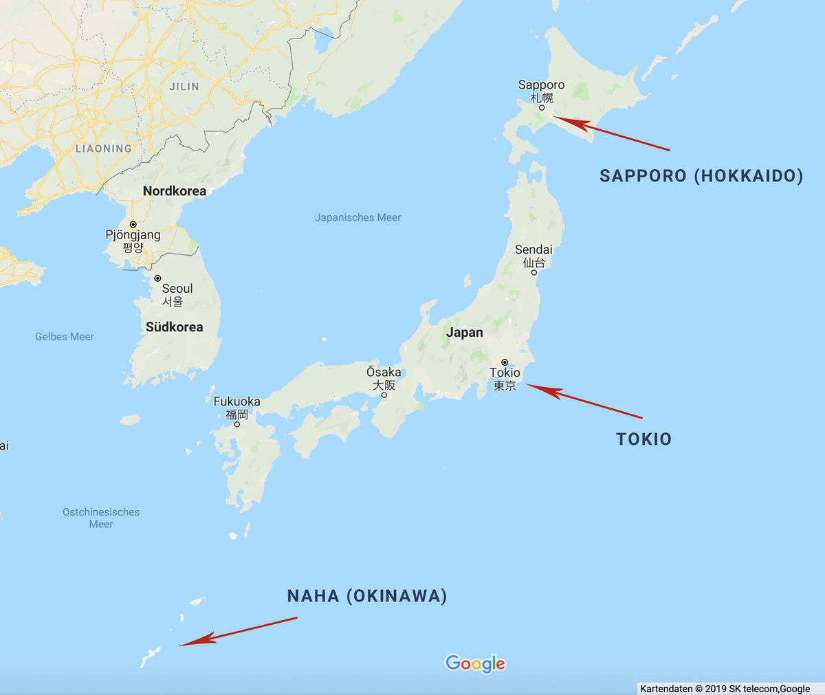
The image is a Google Maps screenshot of Japan and the Korean Peninsula, with three red arrows calling out cities spread across the country's full north-south span. The top arrow points to Sapporo (Hokkaido) on the northern island, the middle arrow marks Tokio on the main island of Honshu, and the third arrow points far to the southwest toward Naha (Okinawa), whose small islands sit near the bottom of the frame. The map's interface language is German, so the sea and country labels read "Japanisches Meer," "Nordkorea," "Südkorea," "Gelbes Meer," and "Ostchinesisches Meer." Other Japanese cities marked with dots include Sendai, Ōsaka, and Fukuoka, and Seoul and Pjöngjang appear on the Korean peninsula. The overall effect is a simple overview map showing how widely separated Japan's northern, central, and subtropical southern regions are.
The image is a Google Maps screenshot of Japan and the Korean Peninsula, with three red arrows calling out cities spread across the country's full north-south span. The top arrow points to Sapporo (Hokkaido) on the northern island, the middle arrow marks Tokio on the main island of Honshu, and the third arrow points far to the southwest toward Naha (Okinawa), whose small islands sit near the bottom of the frame.
The map's interface language is German, so the sea and country labels read "Japanisches Meer," "Nordkorea," "Südkorea," "Gelbes Meer," and "Ostchinesisches Meer." Other Japanese cities marked with dots include Sendai, Ōsaka, and Fukuoka, and Seoul and Pjöngjang appear on the Korean peninsula. The overall effect is a simple overview map showing how widely separated Japan's northern, central, and subtropical southern regions are.
Testo visibile nell'immagine
JILIN
LIAONING
Nordkorea
Pjŏngjang
평양
Seoul
서울
Südkorea
Gelbes Meer
Japanisches Meer
Sapporo
札幌
SAPPORO (HOKKAIDO)
Sendai
仙台
Japan
Ōsaka
大阪
Tokio
東京
Fukuoka
福岡
TOKIO
Ostchinesisches
Meer
NAHA (OKINAWA)
Google
Kartendaten © 2019 SK telecom,Google
Giappone meridionale (Okinawa, Fukuoka; subtropicale)

A sweeping view of a tropical beach in Okinawa, seen from an elevated spot. A long crescent of pale sand curves around a bay of clear turquoise water, with a handful of people scattered along the shore. Palm trees and dense green foliage fill the foreground, where rows of wooden lounge chairs and closed beach umbrellas sit on a terrace overlooking the sand. Across the water, small rocky islets covered in trees rise from the shallows, and hazy green mountains stretch along the horizon under a soft, overcast sky.
A sweeping view of a tropical beach in Okinawa, seen from an elevated spot. A long crescent of pale sand curves around a bay of clear turquoise water, with a handful of people scattered along the shore. Palm trees and dense green foliage fill the foreground, where rows of wooden lounge chairs and closed beach umbrellas sit on a terrace overlooking the sand. Across the water, small rocky islets covered in trees rise from the shallows, and hazy green mountains stretch along the horizon under a soft, overcast sky.
Testo visibile nell'immagine
**Empty response**
Soprattutto Okinawa è un vero paradiso per gli amanti della spiaggia e per tutti coloro che vogliono sfuggire al freddo. Anche a gennaio le temperature medie si attestano sui 17 gradi.
Gli abitanti e i turisti hanno a disposizione spiagge di sabbia bianca quasi tutto l'anno, solo da novembre a febbraio sono chiuse. Tuttavia, è necessario tenere d'occhio la stagione delle piogge e la stagione dei tifoni. La prima inizia a maggio e termina a metà giugno, mentre la seconda dura da luglio a settembre.
Chi viaggia nel sud del Giappone all'inizio dell'anno può godere dei primi fiori di ciliegio, che si fanno vedere già a gennaio in alcune regioni a causa del clima caldo e umido.
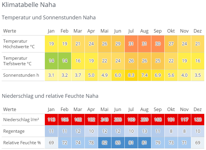
A German-language climate table for Naha on Okinawa, titled Klimatabelle Naha. The first section covers temperature and sunshine hours by month, January through December. Average highs climb from 19 °C in January and February to 31 °C in July and August, while lows range from 14 °C in winter to 26 °C at the height of summer. Sunshine peaks at 8.3 hours a day in July. The cells are color coded, shifting from green and yellow in the cooler months to orange in summer. The second section covers precipitation and relative humidity. Rainfall is substantial all year, from a low of 106 l/m² in February to a high of 259 l/m² in August, and every monthly value is marked in red. Rain days stay modest at 8 to 13 per month. Relative humidity runs from 69 percent in January and December up to 85 percent in June, shown in shades of blue.
A German-language climate table for Naha on Okinawa, titled Klimatabelle Naha. The first section covers temperature and sunshine hours by month, January through December. Average highs climb from 19 °C in January and February to 31 °C in July and August, while lows range from 14 °C in winter to 26 °C at the height of summer. Sunshine peaks at 8.3 hours a day in July. The cells are color coded, shifting from green and yellow in the cooler months to orange in summer.
The second section covers precipitation and relative humidity. Rainfall is substantial all year, from a low of 106 l/m² in February to a high of 259 l/m² in August, and every monthly value is marked in red. Rain days stay modest at 8 to 13 per month. Relative humidity runs from 69 percent in January and December up to 85 percent in June, shown in shades of blue.
Testo visibile nell'immagine
# Klimatabelle Naha
## Temperatur und Sonnenstunden Naha
| Werte | Jan | Feb | Mar | Apr | Mai | Jun | Jul | Aug | Sep | Okt | Nov | Dez |
|---|---|---|---|---|---|---|---|---|---|---|---|---|
| Temperatur Höchstwerte °C | 19 | 19 | 21 | 24 | 26 | 29 | 31 | 31 | 30 | 27 | 24 | 21 |
| Temperatur Tiefstwerte °C | 14 | 14 | 16 | 19 | 22 | 24 | 26 | 26 | 25 | 22 | 19 | 16 |
| Sonnenstunden h | 3.1 | 3.2 | 3.7 | 5.0 | 4.9 | 6.0 | 8.3 | 7.4 | 6.9 | 5.6 | 4.0 | 3.5 |
## Niederschlag und relative Feuchte Naha
| Werte | Jan | Feb | Mar | Apr | Mai | Jun | Jul | Aug | Sep | Okt | Nov | Dez |
|---|---|---|---|---|---|---|---|---|---|---|---|---|
| Niederschlag l/m² | 113 | 106 | 162 | 152 | 243 | 253 | 190 | 259 | 168 | 151 | 117 | 123 |
| Regentage | 11 | 11 | 12 | 10 | 12 | 12 | 10 | 13 | 11 | 8 | 8 | 10 |
| Relative Feuchte % | 69 | 72 | 74 | 78 | 82 | 85 | 81 | 81 | 79 | 73 | 71 | 69 |
Giappone centrale (Tokyo, Osaka, Kyoto; temperato)
Le temperature nel Giappone centrale sono generalmente leggermente più alte che in Germania. In primavera e in autunno si registrano miti 15-20 gradi, il più delle volte soleggiato. Soprattutto ad aprile/maggio e ottobre/novembre il tempo è ideale.
Come nel sud, c'è una stagione delle piogge, che nel Giappone centrale porta soprattutto a giugno e luglio torrenti di pioggia. Le temperature che ne derivano e l'umidità estremamente elevata si protraggono fino a settembre. Proprio ad agosto le temperature sono normalmente di almeno 30 gradi, che si avvertono ancora più pesanti a causa dell'alta umidità.
Da dicembre si fa poi fresco, con -5-10 gradi e neve nelle zone montuose.
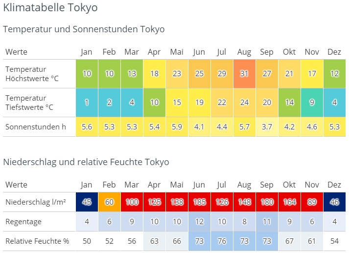
A German-language climate table for Tokyo, headed "Klimatabelle Tokyo," laid out as two color-coded tables with columns for each month from Jan to Dez. The first table, "Temperatur und Sonnenstunden Tokyo," has three rows. Average daily highs climb from 10 °C in January and February to a peak of 31 °C in August, then fall back to 12 °C in December. Lows run from 1 °C in January up to 24 °C in August. Sunshine hours stay between roughly 3.7 (September) and 5.9 per day (May). Each temperature cell is shaded on a scale from blue for the coldest months through green and yellow to red for the hottest. The second table, "Niederschlag und relative Feuchte Tokyo," covers rain. Monthly precipitation is lowest in January and December at 45 and 46 l/m² and highest in June at 185, with August (148) and September (180) also very wet. Rain days range from 4 per month in winter to 12 in June. Relative humidity sits near 50 to 56 percent in winter and reaches 76 percent in July. These cells use a blue-to-red shading, so the rainy summer months stand out in strong red while winter months are dark blue.
A German-language climate table for Tokyo, headed "Klimatabelle Tokyo," laid out as two color-coded tables with columns for each month from Jan to Dez.
The first table, "Temperatur und Sonnenstunden Tokyo," has three rows. Average daily highs climb from 10 °C in January and February to a peak of 31 °C in August, then fall back to 12 °C in December. Lows run from 1 °C in January up to 24 °C in August. Sunshine hours stay between roughly 3.7 (September) and 5.9 per day (May). Each temperature cell is shaded on a scale from blue for the coldest months through green and yellow to red for the hottest.
The second table, "Niederschlag und relative Feuchte Tokyo," covers rain. Monthly precipitation is lowest in January and December at 45 and 46 l/m² and highest in June at 185, with August (148) and September (180) also very wet. Rain days range from 4 per month in winter to 12 in June. Relative humidity sits near 50 to 56 percent in winter and reaches 76 percent in July. These cells use a blue-to-red shading, so the rainy summer months stand out in strong red while winter months are dark blue.
Testo visibile nell'immagine
# Klimatabelle Tokyo
## Temperatur und Sonnenstunden Tokyo
| Werte | Jan | Feb | Mar | Apr | Mai | Jun | Jul | Aug | Sep | Okt | Nov | Dez |
|---|---|---|---|---|---|---|---|---|---|---|---|---|
| Temperatur Höchstwerte °C | 10 | 10 | 13 | 18 | 23 | 25 | 29 | 31 | 27 | 21 | 17 | 12 |
| Temperatur Tiefstwerte °C | 1 | 2 | 4 | 10 | 15 | 19 | 22 | 24 | 20 | 14 | 9 | 4 |
| Sonnenstunden h | 5.6 | 5.3 | 5.3 | 5.4 | 5.9 | 4.1 | 4.4 | 5.7 | 3.7 | 4.2 | 4.6 | 5.3 |
## Niederschlag und relative Feuchte Tokyo
| Werte | Jan | Feb | Mar | Apr | Mai | Jun | Jul | Aug | Sep | Okt | Nov | Dez |
|---|---|---|---|---|---|---|---|---|---|---|---|---|
| Niederschlag l/m² | 45 | 60 | 100 | 125 | 138 | 185 | 126 | 148 | 180 | 164 | 89 | 46 |
| Regentage | 4 | 6 | 9 | 10 | 10 | 12 | 10 | 8 | 11 | 9 | 6 | 4 |
| Relative Feuchte % | 50 | 52 | 56 | 63 | 66 | 73 | 76 | 73 | 73 | 67 | 61 | 54 |
Giappone settentrionale (Aomori, Hokkaido; temperato fresco)
Il Giappone settentrionale è un sogno per tutti gli amanti degli sport invernali e degli escursionisti. Da dicembre a marzo, tutta la regione è ricoperta di neve, a volte alta metri, e le temperature raramente superano i 0 gradi. In estate, ovvero da giugno ad agosto, si può godere della natura a temperature piacevoli di quasi 25 gradi.
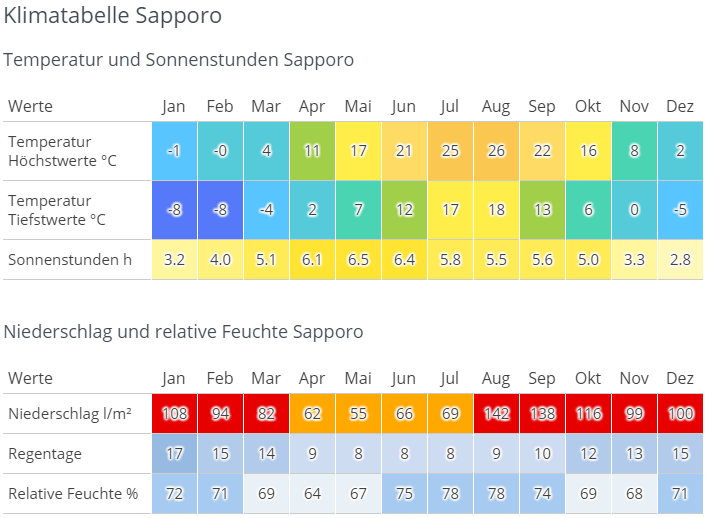
A German-language climate chart for Sapporo on Japan's northern island of Hokkaido, built as two color-coded tables spanning all twelve months. The first table covers temperature and sunshine, with cells shaded from blue in the cold months to yellow and orange in the warm ones. Daily highs sit at -1 and 0 °C in January and February, climb through a mild spring to 21 °C in June, peak at 26 °C in August, and fall back to 2 °C by December. Lows range from -8 °C in midwinter to 18 °C in summer. Sunshine stays modest year round, from 2.8 hours in December up to 6.5 in May. The second table covers moisture. Precipitation bottoms out at 55 liters per square meter in May and peaks at 142 in August and 138 in September, with the wettest cells highlighted in red. Rain days run from 8 in summer to 17 in January, and relative humidity stays between 64 and 78 percent, highest in July and August.
A German-language climate chart for Sapporo on Japan's northern island of Hokkaido, built as two color-coded tables spanning all twelve months. The first table covers temperature and sunshine, with cells shaded from blue in the cold months to yellow and orange in the warm ones. Daily highs sit at -1 and 0 °C in January and February, climb through a mild spring to 21 °C in June, peak at 26 °C in August, and fall back to 2 °C by December. Lows range from -8 °C in midwinter to 18 °C in summer. Sunshine stays modest year round, from 2.8 hours in December up to 6.5 in May.
The second table covers moisture. Precipitation bottoms out at 55 liters per square meter in May and peaks at 142 in August and 138 in September, with the wettest cells highlighted in red. Rain days run from 8 in summer to 17 in January, and relative humidity stays between 64 and 78 percent, highest in July and August.
Testo visibile nell'immagine
# Klimatabelle Sapporo
## Temperatur und Sonnenstunden Sapporo
| Werte | Jan | Feb | Mar | Apr | Mai | Jun | Jul | Aug | Sep | Okt | Nov | Dez |
|---|---|---|---|---|---|---|---|---|---|---|---|---|
| Temperatur Höchstwerte °C | -1 | -0 | 4 | 11 | 17 | 21 | 25 | 26 | 22 | 16 | 8 | 2 |
| Temperatur Tiefstwerte °C | -8 | -8 | -4 | 2 | 7 | 12 | 17 | 18 | 13 | 6 | 0 | -5 |
| Sonnenstunden h | 3.2 | 4.0 | 5.1 | 6.1 | 6.5 | 6.4 | 5.8 | 5.5 | 5.6 | 5.0 | 3.3 | 2.8 |
## Niederschlag und relative Feuchte Sapporo
| Werte | Jan | Feb | Mar | Apr | Mai | Jun | Jul | Aug | Sep | Okt | Nov | Dez |
|---|---|---|---|---|---|---|---|---|---|---|---|---|
| Niederschlag l/m² | 108 | 94 | 82 | 62 | 55 | 66 | 69 | 142 | 138 | 116 | 99 | 100 |
| Regentage | 17 | 15 | 14 | 9 | 8 | 8 | 8 | 9 | 10 | 12 | 13 | 15 |
| Relative Feuchte % | 72 | 71 | 69 | 64 | 67 | 75 | 78 | 78 | 74 | 69 | 68 | 71 |
Clima tedesco vs. clima giapponese
Una cosa in comune tra i due paesi è che entrambi hanno quattro stagioni, chiaramente distinte. Mentre il Giappone settentrionale si avvicina maggiormente al clima tedesco, le temperature nel Giappone centrale sono in media leggermente più alte e nel Giappone meridionale sono notevolmente più alte rispetto alla Germania. L'alta umidità e la stagione delle piogge del Giappone, invece, non si trovano affatto in Germania.
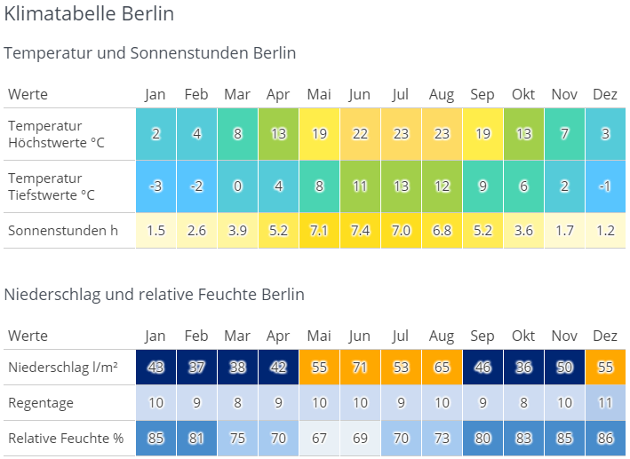
A German-language climate chart for Berlin ("Klimatabelle Berlin") presented as two color-coded tables covering all twelve months. The first table, "Temperatur und Sonnenstunden Berlin," shows three rows: average highs ranging from 2°C in January to 23°C in July and August, average lows from -3°C in January to 13°C in July, and sunshine hours peaking at 7.4 in June. Cells are shaded on a blue-to-yellow gradient so warm months stand out in yellow and cold months in blue-green. The second table, "Niederschlag und relative Feuchte Berlin," covers precipitation in liters per square meter (highest at 71 in June), rainy days per month (mostly 8 to 11), and relative humidity, which is highest in the winter months at 85–86% and lowest in May at 67%. Precipitation cells use a dark-blue-to-orange scale, with the wettest months highlighted in orange.
A German-language climate chart for Berlin ("Klimatabelle Berlin") presented as two color-coded tables covering all twelve months.
The first table, "Temperatur und Sonnenstunden Berlin," shows three rows: average highs ranging from 2°C in January to 23°C in July and August, average lows from -3°C in January to 13°C in July, and sunshine hours peaking at 7.4 in June. Cells are shaded on a blue-to-yellow gradient so warm months stand out in yellow and cold months in blue-green.
The second table, "Niederschlag und relative Feuchte Berlin," covers precipitation in liters per square meter (highest at 71 in June), rainy days per month (mostly 8 to 11), and relative humidity, which is highest in the winter months at 85–86% and lowest in May at 67%. Precipitation cells use a dark-blue-to-orange scale, with the wettest months highlighted in orange.
Testo visibile nell'immagine
# Klimatabelle Berlin
Temperatur und Sonnenstunden Berlin
| Werte | Jan | Feb | Mar | Apr | Mai | Jun | Jul | Aug | Sep | Okt | Nov | Dez |
| --- | --- | --- | --- | --- | --- | --- | --- | --- | --- | --- | --- | --- |
| Temperatur Höchstwerte °C | 2 | 4 | 8 | 13 | 19 | 22 | 23 | 23 | 19 | 13 | 7 | 3 |
| Temperatur Tiefstwerte °C | -3 | -2 | 0 | 4 | 8 | 11 | 13 | 12 | 9 | 6 | 2 | -1 |
| Sonnenstunden h | 1.5 | 2.6 | 3.9 | 5.2 | 7.1 | 7.4 | 7.0 | 6.8 | 5.2 | 3.6 | 1.7 | 1.2 |
Niederschlag und relative Feuchte Berlin
| Werte | Jan | Feb | Mar | Apr | Mai | Jun | Jul | Aug | Sep | Okt | Nov | Dez |
| --- | --- | --- | --- | --- | --- | --- | --- | --- | --- | --- | --- | --- |
| Niederschlag l/m² | 48 | 37 | 38 | 42 | 55 | 71 | 53 | 65 | 46 | 36 | 50 | 55 |
| Regentage | 10 | 9 | 8 | 9 | 10 | 10 | 9 | 10 | 9 | 8 | 10 | 11 |
| Relative Feuchte % | 85 | 81 | 75 | 70 | 67 | 69 | 70 | 73 | 80 | 83 | 85 | 86 |
Da cosa è influenzato il clima giapponese?
Poiché il Giappone si estende su diversi gradi di latitudine, il clima è influenzato da diversi venti e correnti d'aria. In inverno, nel Giappone settentrionale, bisogna prepararsi ai venti siberiani, che portano neve e temperature gelide. Al contrario, in estate, le correnti d'aria tropicali portano pioggia monsonica e calore nel Giappone meridionale. A questo si aggiungono le correnti marine calde e fredde a sud e nord-est, che accentuano ancora di più le differenze climatiche.
Bisogna anche considerare che in Giappone non c'è generalmente la siccità. Può piovere tutto l'anno, con le maggiori precipitazioni nel Giappone centrale e le minori nel nord del paese.
Cosa stai pianificando per il tuo soggiorno in Giappone?
Sport invernali
Hokkaido e anche le regioni settentrionali di Honshu offrono una grande quantità di neve e piste da sci famose in tutto il mondo. Che tu sia un principiante o un esperto, c'è qualcosa per tutti!
Vacanza al mare
Già da marzo si può rilassare sulle spiagge del Giappone meridionale, in particolare Okinawa non ha nulla da invidiare ad altre famose destinazioni turistiche come le Hawaii. Se vuoi soprattutto fare il bagno, dovresti evitare il periodo estivo, perché spesso può piovere. Solo le immersioni o lo snorkeling sono comunque possibili.
Metropola Tokyo
La primavera e l'autunno sono particolarmente adatti, perché la città si riscalda molto in estate e gli inverni possono essere gelidi.
Godersi la natura
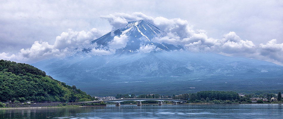
Mount Fuji fills the frame, its snow-streaked summit half swallowed by thick white clouds that drift across the peak and trail down the slopes. The mountain's blue-grey lower flanks stretch down toward a calm lake in the foreground, where a long, low road bridge crosses the water. A densely forested green hill rises on the left bank, and low buildings and trees line the far shore beneath the mountain. It is a classic view of Japan's tallest peak from one of the lakes at its foot, with the spring or early summer snowline still visible above the clouds.
Mount Fuji fills the frame, its snow-streaked summit half swallowed by thick white clouds that drift across the peak and trail down the slopes. The mountain's blue-grey lower flanks stretch down toward a calm lake in the foreground, where a long, low road bridge crosses the water. A densely forested green hill rises on the left bank, and low buildings and trees line the far shore beneath the mountain. It is a classic view of Japan's tallest peak from one of the lakes at its foot, with the spring or early summer snowline still visible above the clouds.
Testo visibile nell'immagine
No clearly readable text.
Soprattutto per gli escursionisti, Hokkaido è consigliabile in estate, perché oltre ai paesaggi mozzafiato ci sono anche temperature miti.
Suggerimento per tutti coloro che non amano il caldo
Se le temperature superiori ai 30 gradi e l'alta umidità sono un incubo per te, dovresti evitare del tutto l'estate nel Giappone centrale e meridionale.
Le 4 stagioni
Primavera
Niente caratterizza la primavera giapponese più della fioritura dei ciliegi. Ogni anno, innumerevoli turisti si recano in Giappone per godersi un mare di bianco e rosa a temperature miti. La primavera è particolarmente popolare tra i viaggiatori in luna di miele!

Estate
Oltre alle spiagge e alle montagne, ci sono anche molti festival estivi diversi che ti faranno dimenticare il caldo estivo - fuochi d'artificio inclusi.

Autunno
In autunno ti aspettano soprattutto temperature piacevoli e il cambio di colore delle foglie degli alberi, che fanno risplendere il paese in rosso, oro e arancio.
Inverno
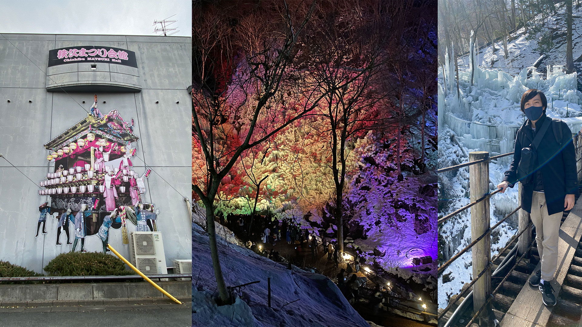
Il periodo migliore per gli amanti degli sport invernali, soprattutto sciatori e snowboarder, trovano pane per i loro denti. Chi preferisce rilassarsi può visitare le sorgenti termali (onsen) o fare una passeggiata nella neve. In inverno vengono anche pescati i migliori frutti di mare.
La mia stagione preferita
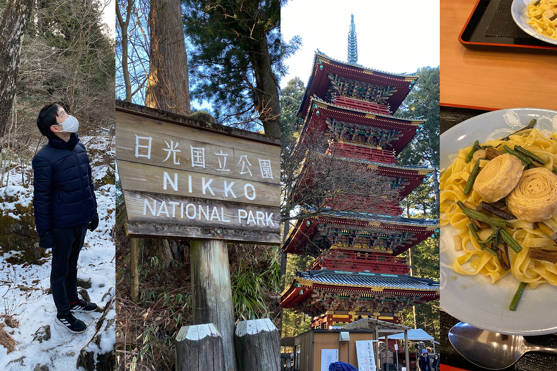
Per me, la primavera e l'autunno sono in cima alla lista, perché non fa troppo freddo, ma nemmeno troppo caldo. Inoltre, il cielo è per lo più limpido, la combinazione perfetta! Confronto l'estate giapponese con una serra o anche con una serra allo zoo. Fa semplicemente caldo, umido e opprimente.
Inoltre, a differenza della Germania, mi sembra che le transizioni tra le stagioni siano più fluide e non così brusche.
Ferie e alta stagione in Giappone
Se possibile, evita l'alta stagione e le festività principali! Non solo prezzi esorbitanti, ma anche folle di persone metteranno alla prova la tua pazienza.
Fioritura dei ciliegi
Il primo grande evento nel calendario giapponese è la fioritura dei ciliegi. Da fine marzo a inizio aprile, turisti e giapponesi si sfidano a vicenda per raggiungere i ciliegi in fiore più belli.
Settimana d'oro
Nella settimana tra la fine di aprile e l'inizio di maggio si concentrano quattro festività diverse e non poche aziende aggiungono ponti. In questo periodo, quasi tutte le destinazioni turistiche popolari sono affollate di turisti giapponesi.
Obon
Molti giapponesi durante queste festività, che cadono intorno al 13 agosto, vanno a trovare la loro famiglia nella città natale, oppure in vacanza. Hokkaido e Okinawa sono in cima alla lista.
Cambio di colore delle foglie in autunno
Il cambio di colore delle foglie in autunno è popolare come la fioritura dei ciliegi. Destinazioni popolari come Kyoto, Hiroshima o anche Tokyo sono particolarmente affollate di turisti alla fine di novembre. Se possibile, i luoghi di interesse dovrebbero essere visitati durante la settimana ed evitati nei fine settimana.
Fine anno
Come per Obon, molti giapponesi durante le festività di Capodanno vanno a trovare la famiglia nella città natale, come i tedeschi a Natale. Naturalmente anche il turismo è in forte espansione in questi giorni.
Suggerimento: subito dopo Capodanno si possono fare molti affari durante i saldi di fine stagione.
Stagione dei tifoni
Ogni anno da giugno a settembre, la stagione dei tifoni porta con sé alte temperature e molte piogge. La maggior parte dei tifoni non colpisce direttamente la terraferma, soprattutto non nella regione di Tokyo. Il sud del paese, in confronto, è molto più colpito. Ma anche se i tifoni forti sono rari, dovresti comunque informarti in anticipo su cosa fare in caso di emergenza. Durante la stagione dei tifoni, le notizie e le previsioni meteorologiche dovrebbero essere monitorate quotidianamente per non essere colti alla sprovvista.
Conclusione
La domanda su quando dovresti andare in Giappone è difficile da rispondere. Il paese è comunque sempre degno di una visita. Ogni regione e ogni stagione ha i suoi momenti salienti e ce n'è per tutti i gusti. La cosa migliore è scegliere ciò che ti interessa di più e cercare il periodo di viaggio in base a questo.
Commenti
Prima impressione per orientarsi. Siamo già stati una volta in Giappone a maggio, nella regione tra Tokyo, Kyoto e Hiroshima. È stato un viaggio stupendo. Ora stiamo pensando di visitare magari il sud. Un saluto, Doreen
Ciao Doreen, sono felice di sapere che ti sia piaciuto. Anche il sud del Giappone è molto bello, spero che vi divertiate altrettanto lì! Cari saluti, Ryusei